You are here: Home > Network List > AV - Alaska Volcano Observatory Stations List
> Station SPCP Crater Peak Broadband, Mount Spurr, Alaska > Earthquake Result Viewer
SPCP Crater Peak Broadband, Mount Spurr, Alaska - Earthquake Result Viewer
| Earthquake location: |
Southeast Of Honshu, Japan |
| Earthquake latitude/longitude: |
32.8/140.6 |
| Earthquake time(UTC): |
2019/07/29 (210) 20:37:42 GMT |
| Earthquake Depth: |
53 km |
| Earthquake Magnitude: |
5.7 Mww |
| Earthquake Catalog/Contributor: |
NEIC PDE/us |
|
| Network: |
AV Alaska Volcano Observatory |
| Station: |
SPCP Crater Peak Broadband, Mount Spurr, Alaska |
| Lat/Lon: |
61.27 N/152.15 W |
| Elevation: |
1616 m |
|
| Distance: |
51.0 deg |
| Az: |
35.015 deg |
| Baz: |
268.254 deg |
| Ray Param: |
0.067570195 |
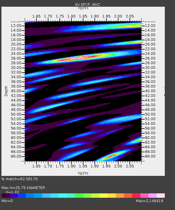
| Estimated Moho Depth: |
25.75 km |
| Estimated Crust Vp/Vs: |
1.82 |
| Assumed Crust Vp: |
6.566 km/s |
| Estimated Crust Vs: |
3.608 km/s |
| Estimated Crust Poisson's Ratio: |
0.28 |
|
| Radial Match: |
92.59178 % |
| Radial Bump: |
400 |
| Transverse Match: |
95.12304 % |
| Transverse Bump: |
353 |
| SOD ConfigId: |
19053131 |
| Insert Time: |
2019-08-12 20:40:23.289 +0000 |
| GWidth: |
2.5 |
| Max Bumps: |
400 |
| Tol: |
0.001 |
|

Signal To Noise
| Channel | StoN | STA | LTA |
| AV:SPCP: :BHZ:20190729T20:46:08.767985Z | 10.734596 | 9.929171E-7 | 9.249692E-8 |
| AV:SPCP: :BHN:20190729T20:46:08.767985Z | 5.2131934 | 6.446972E-7 | 1.2366647E-7 |
| AV:SPCP: :BHE:20190729T20:46:08.767985Z | 2.121022 | 2.489553E-7 | 1.1737516E-7 |
| Arrivals |
| Ps | 3.4 SECOND |
| PpPs | 10 SECOND |
| PsPs/PpSs | 14 SECOND |


