You are here: Home > Network List > TA - USArray Transportable Network (new EarthScope stations) Stations List
> Station U12A Valley of Fire, Overton, NV, USA > Earthquake Result Viewer
U12A Valley of Fire, Overton, NV, USA - Earthquake Result Viewer
| Earthquake location: |
Vanuatu Islands |
| Earthquake latitude/longitude: |
-19.2/168.7 |
| Earthquake time(UTC): |
2007/08/05 (217) 09:28:40 GMT |
| Earthquake Depth: |
45 km |
| Earthquake Magnitude: |
5.6 MB, 5.5 MS, 6.0 MW, 5.9 MW |
| Earthquake Catalog/Contributor: |
WHDF/NEIC |
|
| Network: |
TA USArray Transportable Network (new EarthScope stations) |
| Station: |
U12A Valley of Fire, Overton, NV, USA |
| Lat/Lon: |
36.43 N/114.54 W |
| Elevation: |
644 m |
|
| Distance: |
91.0 deg |
| Az: |
51.73 deg |
| Baz: |
246.969 deg |
| Ray Param: |
0.04162423 |
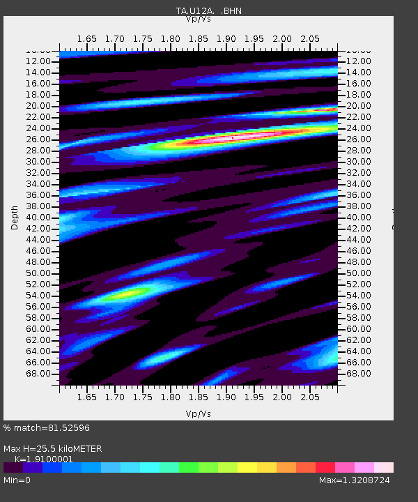
| Estimated Moho Depth: |
25.5 km |
| Estimated Crust Vp/Vs: |
1.91 |
| Assumed Crust Vp: |
6.276 km/s |
| Estimated Crust Vs: |
3.286 km/s |
| Estimated Crust Poisson's Ratio: |
0.31 |
|
| Radial Match: |
81.52596 % |
| Radial Bump: |
400 |
| Transverse Match: |
66.6031 % |
| Transverse Bump: |
400 |
| SOD ConfigId: |
2564 |
| Insert Time: |
2010-03-07 02:24:07.461 +0000 |
| GWidth: |
2.5 |
| Max Bumps: |
400 |
| Tol: |
0.001 |
|

Signal To Noise
| Channel | StoN | STA | LTA |
| TA:U12A: :BHN:20070805T09:41:08.675005Z | 1.2772435 | 5.5769874E-8 | 4.3664247E-8 |
| TA:U12A: :BHE:20070805T09:41:08.675005Z | 1.8990175 | 1.1888174E-7 | 6.260171E-8 |
| TA:U12A: :BHZ:20070805T09:41:08.675005Z | 5.2591515 | 3.734993E-7 | 7.1018924E-8 |
| Arrivals |
| Ps | 3.8 SECOND |
| PpPs | 12 SECOND |
| PsPs/PpSs | 15 SECOND |


