You are here: Home > Network List > TA - USArray Transportable Network (new EarthScope stations) Stations List
> Station U12A Valley of Fire, Overton, NV, USA > Earthquake Result Viewer
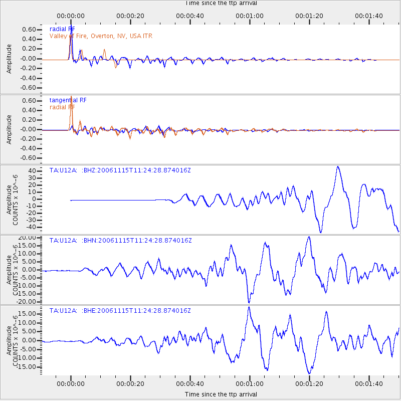
U12A Valley of Fire, Overton, NV, USA - Earthquake Result Viewer
| Earthquake location: |
Kuril Islands |
| Earthquake latitude/longitude: |
46.6/153.3 |
| Earthquake time(UTC): |
2006/11/15 (319) 11:14:13 GMT |
| Earthquake Depth: |
10 km |
| Earthquake Magnitude: |
6.5 MB, 7.8 MS, 8.3 MW, 7.9 MW |
| Earthquake Catalog/Contributor: |
WHDF/NEIC |
|
| Network: |
TA USArray Transportable Network (new EarthScope stations) |
| Station: |
U12A Valley of Fire, Overton, NV, USA |
| Lat/Lon: |
36.43 N/114.54 W |
| Elevation: |
644 m |
|
| Distance: |
66.0 deg |
| Az: |
61.909 deg |
| Baz: |
311.028 deg |
| Ray Param: |
0.057909194 |
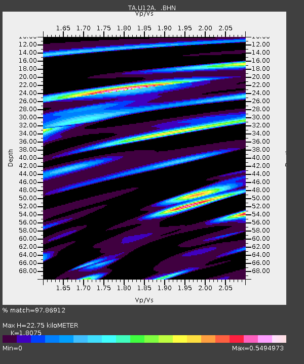
| Estimated Moho Depth: |
22.75 km |
| Estimated Crust Vp/Vs: |
1.81 |
| Assumed Crust Vp: |
6.276 km/s |
| Estimated Crust Vs: |
3.472 km/s |
| Estimated Crust Poisson's Ratio: |
0.28 |
|
| Radial Match: |
97.86912 % |
| Radial Bump: |
367 |
| Transverse Match: |
91.25001 % |
| Transverse Bump: |
400 |
| SOD ConfigId: |
2564 |
| Insert Time: |
2010-03-07 02:24:42.991 +0000 |
| GWidth: |
2.5 |
| Max Bumps: |
400 |
| Tol: |
0.001 |
|
Signal To Noise
| Channel | StoN | STA | LTA |
| TA:U12A: :BHN:20061115T11:24:28.874016Z | 2.2010815 | 5.162738E-7 | 2.345546E-7 |
| TA:U12A: :BHE:20061115T11:24:28.874016Z | 1.7267556 | 3.6724367E-7 | 2.1267843E-7 |
| TA:U12A: :BHZ:20061115T11:24:28.874016Z | 8.88304 | 1.4206531E-6 | 1.599287E-7 |
| Arrivals |
| Ps | 3.0 SECOND |
| PpPs | 9.8 SECOND |
| PsPs/PpSs | 13 SECOND |


