You are here: Home > Network List > TA - USArray Transportable Network (new EarthScope stations) Stations List
> Station U12A Valley of Fire, Overton, NV, USA > Earthquake Result Viewer
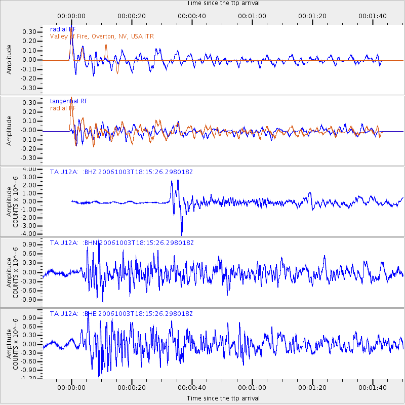
U12A Valley of Fire, Overton, NV, USA - Earthquake Result Viewer
| Earthquake location: |
Vanuatu Islands |
| Earthquake latitude/longitude: |
-18.9/169.0 |
| Earthquake time(UTC): |
2006/10/03 (276) 18:03:14 GMT |
| Earthquake Depth: |
171 km |
| Earthquake Magnitude: |
5.9 MB, 6.3 MW, 6.3 MW |
| Earthquake Catalog/Contributor: |
WHDF/NEIC |
|
| Network: |
TA USArray Transportable Network (new EarthScope stations) |
| Station: |
U12A Valley of Fire, Overton, NV, USA |
| Lat/Lon: |
36.43 N/114.54 W |
| Elevation: |
644 m |
|
| Distance: |
90.6 deg |
| Az: |
51.637 deg |
| Baz: |
247.022 deg |
| Ray Param: |
0.04162192 |
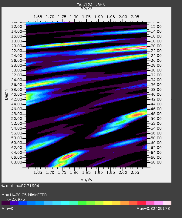
| Estimated Moho Depth: |
20.25 km |
| Estimated Crust Vp/Vs: |
2.10 |
| Assumed Crust Vp: |
6.276 km/s |
| Estimated Crust Vs: |
2.992 km/s |
| Estimated Crust Poisson's Ratio: |
0.35 |
|
| Radial Match: |
87.71904 % |
| Radial Bump: |
400 |
| Transverse Match: |
77.37369 % |
| Transverse Bump: |
400 |
| SOD ConfigId: |
2665 |
| Insert Time: |
2010-03-07 02:24:55.593 +0000 |
| GWidth: |
2.5 |
| Max Bumps: |
400 |
| Tol: |
0.001 |
|
Signal To Noise
| Channel | StoN | STA | LTA |
| TA:U12A: :BHN:20061003T18:15:26.298018Z | 1.4921128 | 9.110039E-8 | 6.105463E-8 |
| TA:U12A: :BHE:20061003T18:15:26.298018Z | 2.871399 | 1.9043176E-7 | 6.6320204E-8 |
| TA:U12A: :BHZ:20061003T18:15:26.298018Z | 10.362746 | 8.994391E-7 | 8.679544E-8 |
| Arrivals |
| Ps | 3.6 SECOND |
| PpPs | 9.8 SECOND |
| PsPs/PpSs | 13 SECOND |


