You are here: Home > Network List > TA - USArray Transportable Network (new EarthScope stations) Stations List
> Station U12A Valley of Fire, Overton, NV, USA > Earthquake Result Viewer
U12A Valley of Fire, Overton, NV, USA - Earthquake Result Viewer
| Earthquake location: |
Near Coast Of Guatemala |
| Earthquake latitude/longitude: |
13.8/-90.8 |
| Earthquake time(UTC): |
2007/06/08 (159) 13:32:00 GMT |
| Earthquake Depth: |
48 km |
| Earthquake Magnitude: |
5.5 MB, 5.4 MS, 5.8 MW, 5.8 MW |
| Earthquake Catalog/Contributor: |
WHDF/NEIC |
|
| Network: |
TA USArray Transportable Network (new EarthScope stations) |
| Station: |
U12A Valley of Fire, Overton, NV, USA |
| Lat/Lon: |
36.43 N/114.54 W |
| Elevation: |
644 m |
|
| Distance: |
31.0 deg |
| Az: |
320.827 deg |
| Baz: |
130.463 deg |
| Ray Param: |
0.07913196 |
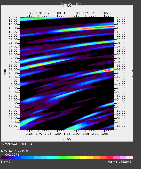
| Estimated Moho Depth: |
37.5 km |
| Estimated Crust Vp/Vs: |
2.10 |
| Assumed Crust Vp: |
6.276 km/s |
| Estimated Crust Vs: |
2.992 km/s |
| Estimated Crust Poisson's Ratio: |
0.35 |
|
| Radial Match: |
81.911674 % |
| Radial Bump: |
400 |
| Transverse Match: |
73.5877 % |
| Transverse Bump: |
400 |
| SOD ConfigId: |
2564 |
| Insert Time: |
2010-03-07 02:25:12.634 +0000 |
| GWidth: |
2.5 |
| Max Bumps: |
400 |
| Tol: |
0.001 |
|

Signal To Noise
| Channel | StoN | STA | LTA |
| TA:U12A: :BHN:20070608T13:37:43.275005Z | 3.581904 | 2.9967507E-7 | 8.366362E-8 |
| TA:U12A: :BHE:20070608T13:37:43.275005Z | 5.672262 | 3.3421068E-7 | 5.8920175E-8 |
| TA:U12A: :BHZ:20070608T13:37:43.275005Z | 9.88305 | 6.126374E-7 | 6.198869E-8 |
| Arrivals |
| Ps | 7.0 SECOND |
| PpPs | 17 SECOND |
| PsPs/PpSs | 24 SECOND |


