You are here: Home > Network List > TA - USArray Transportable Network (new EarthScope stations) Stations List
> Station U04C Hernandez Reservoir, Idria, CA, USA > Earthquake Result Viewer
U04C Hernandez Reservoir, Idria, CA, USA - Earthquake Result Viewer
| Earthquake location: |
Off East Coast Of Honshu, Japan |
| Earthquake latitude/longitude: |
38.1/144.9 |
| Earthquake time(UTC): |
2005/11/14 (318) 21:38:51 GMT |
| Earthquake Depth: |
11 km |
| Earthquake Magnitude: |
6.7 MB, 6.8 MS, 7.0 MW, 6.9 MW |
| Earthquake Catalog/Contributor: |
WHDF/NEIC |
|
| Network: |
TA USArray Transportable Network (new EarthScope stations) |
| Station: |
U04C Hernandez Reservoir, Idria, CA, USA |
| Lat/Lon: |
36.36 N/120.78 W |
| Elevation: |
813 m |
|
| Distance: |
71.7 deg |
| Az: |
57.994 deg |
| Baz: |
304.028 deg |
| Ray Param: |
0.054184023 |
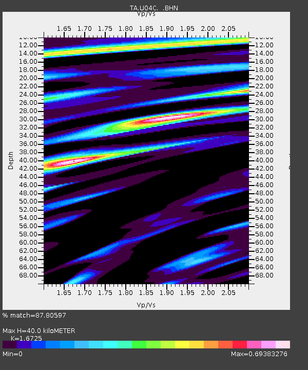
| Estimated Moho Depth: |
40.0 km |
| Estimated Crust Vp/Vs: |
1.67 |
| Assumed Crust Vp: |
6.391 km/s |
| Estimated Crust Vs: |
3.821 km/s |
| Estimated Crust Poisson's Ratio: |
0.22 |
|
| Radial Match: |
87.80597 % |
| Radial Bump: |
400 |
| Transverse Match: |
89.26623 % |
| Transverse Bump: |
400 |
| SOD ConfigId: |
2448 |
| Insert Time: |
2010-03-07 02:25:34.846 +0000 |
| GWidth: |
2.5 |
| Max Bumps: |
400 |
| Tol: |
0.001 |
|
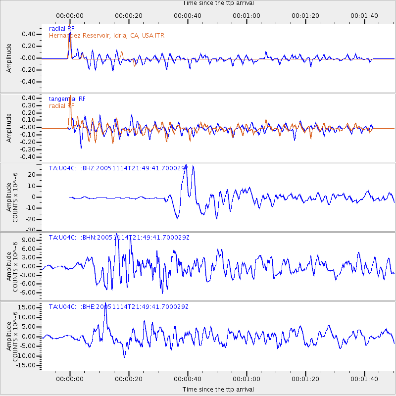
Signal To Noise
| Channel | StoN | STA | LTA |
| TA:U04C: :BHN:20051114T21:49:41.700029Z | 1.2956488 | 7.4987173E-7 | 5.7876156E-7 |
| TA:U04C: :BHE:20051114T21:49:41.700029Z | 1.5786804 | 8.9406365E-7 | 5.6633604E-7 |
| TA:U04C: :BHZ:20051114T21:49:41.700029Z | 3.1327662 | 1.5114098E-6 | 4.824521E-7 |
| Arrivals |
| Ps | 4.4 SECOND |
| PpPs | 16 SECOND |
| PsPs/PpSs | 20 SECOND |


