You are here: Home > Network List > TA - USArray Transportable Network (new EarthScope stations) Stations List
> Station U04C Hernandez Reservoir, Idria, CA, USA > Earthquake Result Viewer
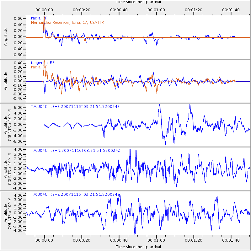
U04C Hernandez Reservoir, Idria, CA, USA - Earthquake Result Viewer
| Earthquake location: |
Peru-Ecuador Border Region |
| Earthquake latitude/longitude: |
-2.3/-77.8 |
| Earthquake time(UTC): |
2007/11/16 (320) 03:13:00 GMT |
| Earthquake Depth: |
123 km |
| Earthquake Magnitude: |
6.3 MB, 6.8 MW, 6.7 MW |
| Earthquake Catalog/Contributor: |
WHDF/NEIC |
|
| Network: |
TA USArray Transportable Network (new EarthScope stations) |
| Station: |
U04C Hernandez Reservoir, Idria, CA, USA |
| Lat/Lon: |
36.36 N/120.78 W |
| Elevation: |
813 m |
|
| Distance: |
55.5 deg |
| Az: |
318.129 deg |
| Baz: |
124.285 deg |
| Ray Param: |
0.064381875 |
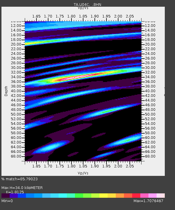
| Estimated Moho Depth: |
34.0 km |
| Estimated Crust Vp/Vs: |
1.81 |
| Assumed Crust Vp: |
6.391 km/s |
| Estimated Crust Vs: |
3.526 km/s |
| Estimated Crust Poisson's Ratio: |
0.28 |
|
| Radial Match: |
85.79023 % |
| Radial Bump: |
400 |
| Transverse Match: |
75.19987 % |
| Transverse Bump: |
400 |
| SOD ConfigId: |
2564 |
| Insert Time: |
2010-03-07 02:25:45.462 +0000 |
| GWidth: |
2.5 |
| Max Bumps: |
400 |
| Tol: |
0.001 |
|
Signal To Noise
| Channel | StoN | STA | LTA |
| TA:U04C: :BHN:20071116T03:21:51.520024Z | 1.5540406 | 4.6172767E-7 | 2.971143E-7 |
| TA:U04C: :BHE:20071116T03:21:51.520024Z | 4.053307 | 1.0824323E-6 | 2.6704916E-7 |
| TA:U04C: :BHZ:20071116T03:21:51.520024Z | 2.7968225 | 1.4056801E-6 | 5.02599E-7 |
| Arrivals |
| Ps | 4.5 SECOND |
| PpPs | 14 SECOND |
| PsPs/PpSs | 19 SECOND |


