You are here: Home > Network List > TA - USArray Transportable Network (new EarthScope stations) Stations List
> Station U04C Hernandez Reservoir, Idria, CA, USA > Earthquake Result Viewer
U04C Hernandez Reservoir, Idria, CA, USA - Earthquake Result Viewer
| Earthquake location: |
Near Coast Of Peru |
| Earthquake latitude/longitude: |
-13.4/-76.6 |
| Earthquake time(UTC): |
2007/08/15 (227) 23:40:57 GMT |
| Earthquake Depth: |
39 km |
| Earthquake Magnitude: |
6.7 MB, 7.9 MS, 8.0 MW, 7.5 ME |
| Earthquake Catalog/Contributor: |
WHDF/NEIC |
|
| Network: |
TA USArray Transportable Network (new EarthScope stations) |
| Station: |
U04C Hernandez Reservoir, Idria, CA, USA |
| Lat/Lon: |
36.36 N/120.78 W |
| Elevation: |
813 m |
|
| Distance: |
64.7 deg |
| Az: |
321.518 deg |
| Baz: |
131.388 deg |
| Ray Param: |
0.05869258 |
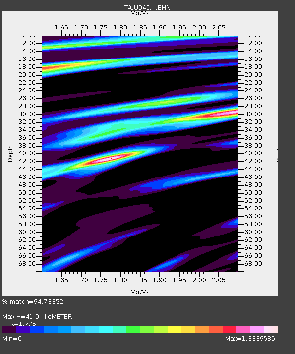
| Estimated Moho Depth: |
41.0 km |
| Estimated Crust Vp/Vs: |
1.77 |
| Assumed Crust Vp: |
6.391 km/s |
| Estimated Crust Vs: |
3.6 km/s |
| Estimated Crust Poisson's Ratio: |
0.27 |
|
| Radial Match: |
94.73352 % |
| Radial Bump: |
400 |
| Transverse Match: |
85.57565 % |
| Transverse Bump: |
400 |
| SOD ConfigId: |
2564 |
| Insert Time: |
2010-03-07 02:25:57.470 +0000 |
| GWidth: |
2.5 |
| Max Bumps: |
400 |
| Tol: |
0.001 |
|
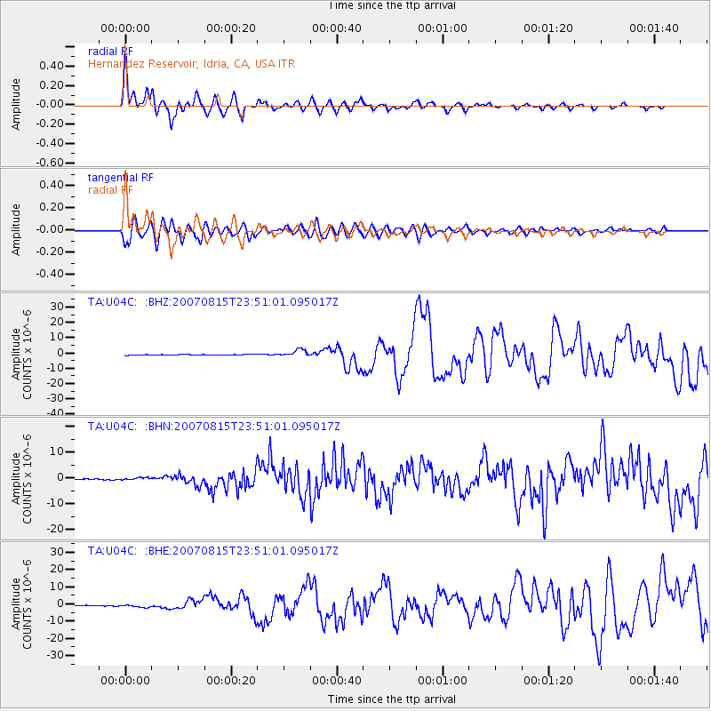
Signal To Noise
| Channel | StoN | STA | LTA |
| TA:U04C: :BHN:20070815T23:51:01.095017Z | 2.370864 | 4.8724763E-7 | 2.0551481E-7 |
| TA:U04C: :BHE:20070815T23:51:01.095017Z | 6.0072813 | 8.6158036E-7 | 1.4342268E-7 |
| TA:U04C: :BHZ:20070815T23:51:01.095017Z | 12.676203 | 2.2620827E-6 | 1.7845113E-7 |
| Arrivals |
| Ps | 5.2 SECOND |
| PpPs | 17 SECOND |
| PsPs/PpSs | 22 SECOND |


