You are here: Home > Network List > TA - USArray Transportable Network (new EarthScope stations) Stations List
> Station E20K Nigu River, AK, USA > Earthquake Result Viewer
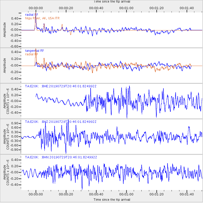
E20K Nigu River, AK, USA - Earthquake Result Viewer
*The percent match for this event was below the threshold and hence no stack was calculated.
| Earthquake location: |
Southeast Of Honshu, Japan |
| Earthquake latitude/longitude: |
32.8/140.6 |
| Earthquake time(UTC): |
2019/07/29 (210) 20:37:42 GMT |
| Earthquake Depth: |
53 km |
| Earthquake Magnitude: |
5.7 Mww |
| Earthquake Catalog/Contributor: |
NEIC PDE/us |
|
| Network: |
TA USArray Transportable Network (new EarthScope stations) |
| Station: |
E20K Nigu River, AK, USA |
| Lat/Lon: |
68.26 N/156.19 W |
| Elevation: |
866 m |
|
| Distance: |
50.1 deg |
| Az: |
25.722 deg |
| Baz: |
258.686 deg |
| Ray Param: |
$rayparam |
*The percent match for this event was below the threshold and hence was not used in the summary stack. |
|
| Radial Match: |
64.78583 % |
| Radial Bump: |
400 |
| Transverse Match: |
62.418396 % |
| Transverse Bump: |
400 |
| SOD ConfigId: |
19053131 |
| Insert Time: |
2019-08-12 20:47:10.162 +0000 |
| GWidth: |
2.5 |
| Max Bumps: |
400 |
| Tol: |
0.001 |
|
Signal To Noise
| Channel | StoN | STA | LTA |
| TA:E20K: :BHZ:20190729T20:46:01.824992Z | 4.68254 | 2.6848892E-7 | 5.733831E-8 |
| TA:E20K: :BHN:20190729T20:46:01.824992Z | 1.3659445 | 8.334407E-8 | 6.1015704E-8 |
| TA:E20K: :BHE:20190729T20:46:01.824992Z | 1.9123315 | 1.6781725E-7 | 8.775531E-8 |
| Arrivals |
| Ps | |
| PpPs | |
| PsPs/PpSs | |


