You are here: Home > Network List > TA - USArray Transportable Network (new EarthScope stations) Stations List
> Station G16K Koyuk River, AK, USA > Earthquake Result Viewer
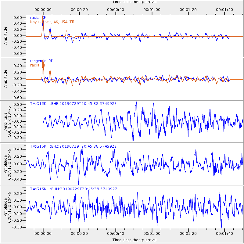
G16K Koyuk River, AK, USA - Earthquake Result Viewer
*The percent match for this event was below the threshold and hence no stack was calculated.
| Earthquake location: |
Southeast Of Honshu, Japan |
| Earthquake latitude/longitude: |
32.8/140.6 |
| Earthquake time(UTC): |
2019/07/29 (210) 20:37:42 GMT |
| Earthquake Depth: |
53 km |
| Earthquake Magnitude: |
5.7 Mww |
| Earthquake Catalog/Contributor: |
NEIC PDE/us |
|
| Network: |
TA USArray Transportable Network (new EarthScope stations) |
| Station: |
G16K Koyuk River, AK, USA |
| Lat/Lon: |
65.39 N/162.35 W |
| Elevation: |
169 m |
|
| Distance: |
47.0 deg |
| Az: |
28.715 deg |
| Baz: |
255.003 deg |
| Ray Param: |
$rayparam |
*The percent match for this event was below the threshold and hence was not used in the summary stack. |
|
| Radial Match: |
70.778435 % |
| Radial Bump: |
400 |
| Transverse Match: |
59.972034 % |
| Transverse Bump: |
400 |
| SOD ConfigId: |
19053131 |
| Insert Time: |
2019-08-12 20:47:24.140 +0000 |
| GWidth: |
2.5 |
| Max Bumps: |
400 |
| Tol: |
0.001 |
|
Signal To Noise
| Channel | StoN | STA | LTA |
| TA:G16K: :BHZ:20190729T20:45:38.574992Z | 4.178848 | 1.9557116E-7 | 4.6800263E-8 |
| TA:G16K: :BHN:20190729T20:45:38.574992Z | 1.4156008 | 6.8863784E-8 | 4.8646328E-8 |
| TA:G16K: :BHE:20190729T20:45:38.574992Z | 1.9721241 | 1.2247692E-7 | 6.2104064E-8 |
| Arrivals |
| Ps | |
| PpPs | |
| PsPs/PpSs | |


