You are here: Home > Network List > IU - Global Seismograph Network (GSN - IRIS/USGS) Stations List
> Station RSSD Black Hills, South Dakota, USA > Earthquake Result Viewer
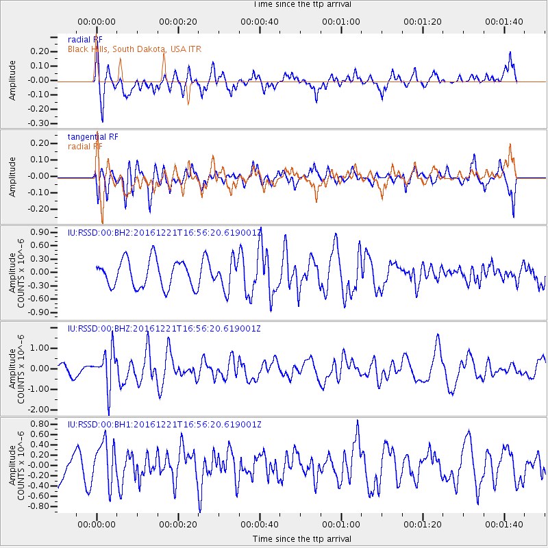
RSSD Black Hills, South Dakota, USA - Earthquake Result Viewer
*The percent match for this event was below the threshold and hence no stack was calculated.
| Earthquake location: |
Mariana Islands Region |
| Earthquake latitude/longitude: |
21.5/145.4 |
| Earthquake time(UTC): |
2016/12/21 (356) 16:43:58 GMT |
| Earthquake Depth: |
17 km |
| Earthquake Magnitude: |
5.9 Mwb |
| Earthquake Catalog/Contributor: |
NEIC PDE/us |
|
| Network: |
IU Global Seismograph Network (GSN - IRIS/USGS) |
| Station: |
RSSD Black Hills, South Dakota, USA |
| Lat/Lon: |
44.12 N/104.04 W |
| Elevation: |
2090 m |
|
| Distance: |
89.0 deg |
| Az: |
42.402 deg |
| Baz: |
299.334 deg |
| Ray Param: |
$rayparam |
*The percent match for this event was below the threshold and hence was not used in the summary stack. |
|
| Radial Match: |
61.842613 % |
| Radial Bump: |
400 |
| Transverse Match: |
49.77392 % |
| Transverse Bump: |
400 |
| SOD ConfigId: |
1894071 |
| Insert Time: |
2017-01-04 16:46:26.851 +0000 |
| GWidth: |
2.5 |
| Max Bumps: |
400 |
| Tol: |
0.001 |
|
Signal To Noise
| Channel | StoN | STA | LTA |
| IU:RSSD:00:BHZ:20161221T16:56:20.619001Z | 4.125265 | 8.982433E-7 | 2.1774196E-7 |
| IU:RSSD:00:BH1:20161221T16:56:20.619001Z | 1.3918402 | 4.0554988E-7 | 2.9137675E-7 |
| IU:RSSD:00:BH2:20161221T16:56:20.619001Z | 1.0738933 | 3.2533637E-7 | 3.0295038E-7 |
| Arrivals |
| Ps | |
| PpPs | |
| PsPs/PpSs | |


