You are here: Home > Network List > TA - USArray Transportable Network (new EarthScope stations) Stations List
> Station K17K Iditarod, AK, USA > Earthquake Result Viewer
K17K Iditarod, AK, USA - Earthquake Result Viewer
| Earthquake location: |
Southeast Of Honshu, Japan |
| Earthquake latitude/longitude: |
32.8/140.6 |
| Earthquake time(UTC): |
2019/07/29 (210) 20:37:42 GMT |
| Earthquake Depth: |
53 km |
| Earthquake Magnitude: |
5.7 Mww |
| Earthquake Catalog/Contributor: |
NEIC PDE/us |
|
| Network: |
TA USArray Transportable Network (new EarthScope stations) |
| Station: |
K17K Iditarod, AK, USA |
| Lat/Lon: |
62.72 N/158.30 W |
| Elevation: |
339 m |
|
| Distance: |
48.2 deg |
| Az: |
32.769 deg |
| Baz: |
261.378 deg |
| Ray Param: |
0.06936209 |
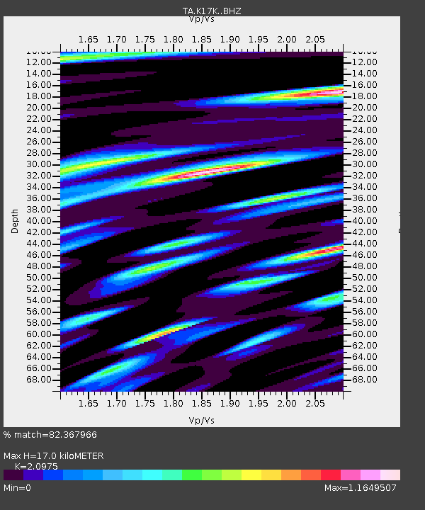
| Estimated Moho Depth: |
17.0 km |
| Estimated Crust Vp/Vs: |
2.10 |
| Assumed Crust Vp: |
6.276 km/s |
| Estimated Crust Vs: |
2.992 km/s |
| Estimated Crust Poisson's Ratio: |
0.35 |
|
| Radial Match: |
82.367966 % |
| Radial Bump: |
400 |
| Transverse Match: |
79.07892 % |
| Transverse Bump: |
400 |
| SOD ConfigId: |
19053131 |
| Insert Time: |
2019-08-12 20:47:51.563 +0000 |
| GWidth: |
2.5 |
| Max Bumps: |
400 |
| Tol: |
0.001 |
|

Signal To Noise
| Channel | StoN | STA | LTA |
| TA:K17K: :BHZ:20190729T20:45:47.824992Z | 8.311869 | 3.836477E-7 | 4.615661E-8 |
| TA:K17K: :BHN:20190729T20:45:47.824992Z | 1.4675269 | 7.548793E-8 | 5.143887E-8 |
| TA:K17K: :BHE:20190729T20:45:47.824992Z | 3.651512 | 2.0265337E-7 | 5.5498486E-8 |
| Arrivals |
| Ps | 3.1 SECOND |
| PpPs | 8.0 SECOND |
| PsPs/PpSs | 11 SECOND |


