You are here: Home > Network List > TA - USArray Transportable Network (new EarthScope stations) Stations List
> Station U04C Hernandez Reservoir, Idria, CA, USA > Earthquake Result Viewer
U04C Hernandez Reservoir, Idria, CA, USA - Earthquake Result Viewer
| Earthquake location: |
Kuril Islands |
| Earthquake latitude/longitude: |
46.5/153.2 |
| Earthquake time(UTC): |
2006/10/01 (274) 09:06:02 GMT |
| Earthquake Depth: |
19 km |
| Earthquake Magnitude: |
6.1 MB, 6.4 MS, 6.6 MW, 6.5 MW |
| Earthquake Catalog/Contributor: |
WHDF/NEIC |
|
| Network: |
TA USArray Transportable Network (new EarthScope stations) |
| Station: |
U04C Hernandez Reservoir, Idria, CA, USA |
| Lat/Lon: |
36.36 N/120.78 W |
| Elevation: |
813 m |
|
| Distance: |
62.2 deg |
| Az: |
65.492 deg |
| Baz: |
308.819 deg |
| Ray Param: |
0.06033664 |
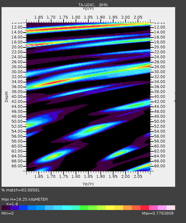
| Estimated Moho Depth: |
19.25 km |
| Estimated Crust Vp/Vs: |
1.60 |
| Assumed Crust Vp: |
6.391 km/s |
| Estimated Crust Vs: |
3.994 km/s |
| Estimated Crust Poisson's Ratio: |
0.18 |
|
| Radial Match: |
83.88581 % |
| Radial Bump: |
400 |
| Transverse Match: |
77.705505 % |
| Transverse Bump: |
400 |
| SOD ConfigId: |
2665 |
| Insert Time: |
2010-03-07 02:26:24.471 +0000 |
| GWidth: |
2.5 |
| Max Bumps: |
400 |
| Tol: |
0.001 |
|
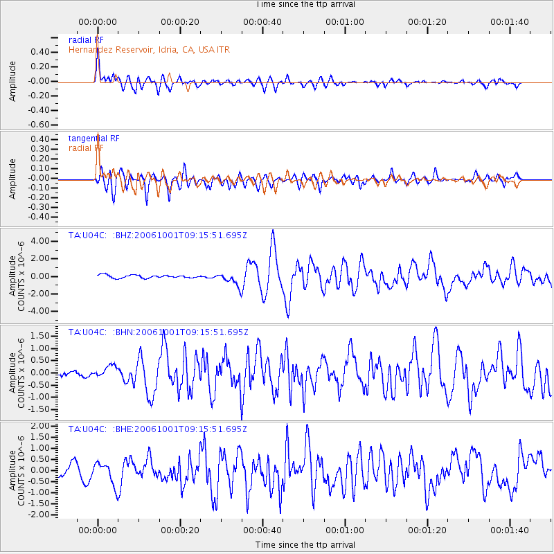
Signal To Noise
| Channel | StoN | STA | LTA |
| TA:U04C: :BHN:20061001T09:15:51.695Z | 2.5405612 | 2.5025022E-7 | 9.850194E-8 |
| TA:U04C: :BHE:20061001T09:15:51.695Z | 1.8331347 | 5.204477E-7 | 2.8391136E-7 |
| TA:U04C: :BHZ:20061001T09:15:51.695Z | 4.5641804 | 7.925756E-7 | 1.7365124E-7 |
| Arrivals |
| Ps | 1.9 SECOND |
| PpPs | 7.5 SECOND |
| PsPs/PpSs | 9.4 SECOND |


