You are here: Home > Network List > TA - USArray Transportable Network (new EarthScope stations) Stations List
> Station L15K Ungalak Mountain, AK, USA > Earthquake Result Viewer
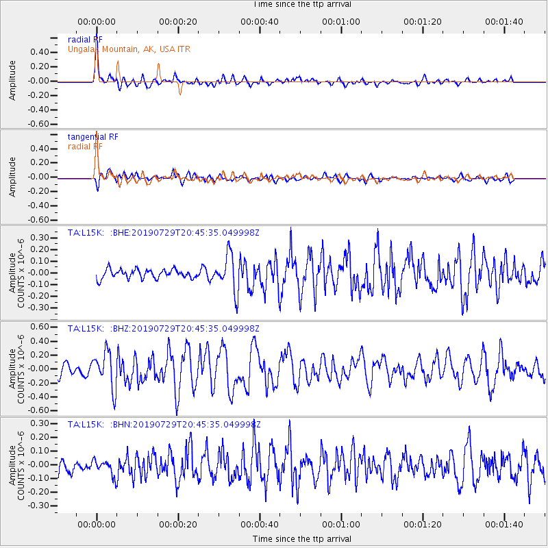
L15K Ungalak Mountain, AK, USA - Earthquake Result Viewer
*The percent match for this event was below the threshold and hence no stack was calculated.
| Earthquake location: |
Southeast Of Honshu, Japan |
| Earthquake latitude/longitude: |
32.8/140.6 |
| Earthquake time(UTC): |
2019/07/29 (210) 20:37:42 GMT |
| Earthquake Depth: |
53 km |
| Earthquake Magnitude: |
5.7 Mww |
| Earthquake Catalog/Contributor: |
NEIC PDE/us |
|
| Network: |
TA USArray Transportable Network (new EarthScope stations) |
| Station: |
L15K Ungalak Mountain, AK, USA |
| Lat/Lon: |
61.68 N/161.49 W |
| Elevation: |
219 m |
|
| Distance: |
46.6 deg |
| Az: |
33.823 deg |
| Baz: |
259.278 deg |
| Ray Param: |
$rayparam |
*The percent match for this event was below the threshold and hence was not used in the summary stack. |
|
| Radial Match: |
78.79399 % |
| Radial Bump: |
400 |
| Transverse Match: |
74.39782 % |
| Transverse Bump: |
400 |
| SOD ConfigId: |
19053131 |
| Insert Time: |
2019-08-12 20:47:55.022 +0000 |
| GWidth: |
2.5 |
| Max Bumps: |
400 |
| Tol: |
0.001 |
|
Signal To Noise
| Channel | StoN | STA | LTA |
| TA:L15K: :BHZ:20190729T20:45:35.049998Z | 3.931035 | 2.6960606E-7 | 6.8583994E-8 |
| TA:L15K: :BHN:20190729T20:45:35.049998Z | 1.6628784 | 5.9364993E-8 | 3.570014E-8 |
| TA:L15K: :BHE:20190729T20:45:35.049998Z | 4.3702636 | 1.6484505E-7 | 3.7719705E-8 |
| Arrivals |
| Ps | |
| PpPs | |
| PsPs/PpSs | |


