You are here: Home > Network List > TA - USArray Transportable Network (new EarthScope stations) Stations List
> Station U04C Hernandez Reservoir, Idria, CA, USA > Earthquake Result Viewer
U04C Hernandez Reservoir, Idria, CA, USA - Earthquake Result Viewer
| Earthquake location: |
Chile-Argentina Border Region |
| Earthquake latitude/longitude: |
-24.4/-67.0 |
| Earthquake time(UTC): |
2006/08/25 (237) 00:44:46 GMT |
| Earthquake Depth: |
184 km |
| Earthquake Magnitude: |
5.9 MB, 6.6 MW, 6.6 MW |
| Earthquake Catalog/Contributor: |
WHDF/NEIC |
|
| Network: |
TA USArray Transportable Network (new EarthScope stations) |
| Station: |
U04C Hernandez Reservoir, Idria, CA, USA |
| Lat/Lon: |
36.36 N/120.78 W |
| Elevation: |
813 m |
|
| Distance: |
78.9 deg |
| Az: |
318.441 deg |
| Baz: |
131.471 deg |
| Ray Param: |
0.048869338 |
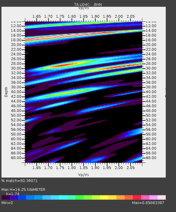
| Estimated Moho Depth: |
16.25 km |
| Estimated Crust Vp/Vs: |
1.74 |
| Assumed Crust Vp: |
6.391 km/s |
| Estimated Crust Vs: |
3.673 km/s |
| Estimated Crust Poisson's Ratio: |
0.25 |
|
| Radial Match: |
80.39071 % |
| Radial Bump: |
400 |
| Transverse Match: |
70.65337 % |
| Transverse Bump: |
400 |
| SOD ConfigId: |
2665 |
| Insert Time: |
2010-03-07 02:26:27.686 +0000 |
| GWidth: |
2.5 |
| Max Bumps: |
400 |
| Tol: |
0.001 |
|
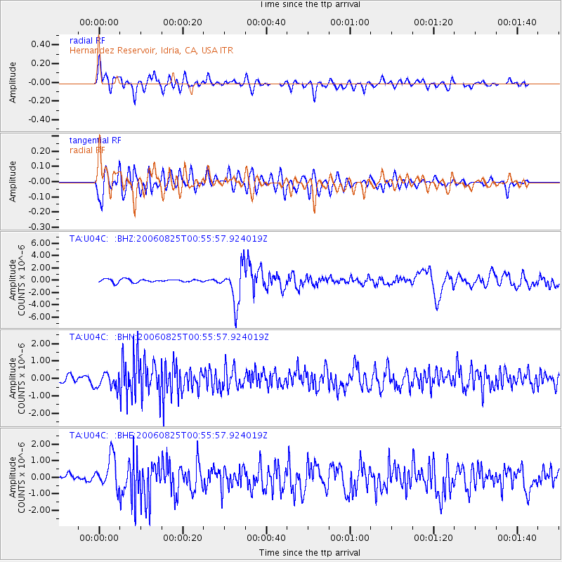
Signal To Noise
| Channel | StoN | STA | LTA |
| TA:U04C: :BHN:20060825T00:55:57.924019Z | 1.9364351 | 4.1746483E-7 | 2.155842E-7 |
| TA:U04C: :BHE:20060825T00:55:57.924019Z | 4.79719 | 9.890003E-7 | 2.0616241E-7 |
| TA:U04C: :BHZ:20060825T00:55:57.924019Z | 12.699053 | 3.1329153E-6 | 2.4670464E-7 |
| Arrivals |
| Ps | 1.9 SECOND |
| PpPs | 6.8 SECOND |
| PsPs/PpSs | 8.7 SECOND |


