You are here: Home > Network List > TA - USArray Transportable Network (new EarthScope stations) Stations List
> Station N20K Mount Spurr, AK, USA > Earthquake Result Viewer
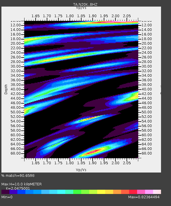
N20K Mount Spurr, AK, USA - Earthquake Result Viewer
| Earthquake location: |
Southeast Of Honshu, Japan |
| Earthquake latitude/longitude: |
32.8/140.6 |
| Earthquake time(UTC): |
2019/07/29 (210) 20:37:42 GMT |
| Earthquake Depth: |
53 km |
| Earthquake Magnitude: |
5.7 Mww |
| Earthquake Catalog/Contributor: |
NEIC PDE/us |
|
| Network: |
TA USArray Transportable Network (new EarthScope stations) |
| Station: |
N20K Mount Spurr, AK, USA |
| Lat/Lon: |
61.20 N/152.21 W |
| Elevation: |
991 m |
|
| Distance: |
50.9 deg |
| Az: |
35.098 deg |
| Baz: |
268.26 deg |
| Ray Param: |
0.06758764 |
| Estimated Moho Depth: |
10.0 km |
| Estimated Crust Vp/Vs: |
2.05 |
| Assumed Crust Vp: |
6.566 km/s |
| Estimated Crust Vs: |
3.207 km/s |
| Estimated Crust Poisson's Ratio: |
0.34 |
|
| Radial Match: |
90.6598 % |
| Radial Bump: |
400 |
| Transverse Match: |
85.93146 % |
| Transverse Bump: |
400 |
| SOD ConfigId: |
19053131 |
| Insert Time: |
2019-08-12 20:48:12.514 +0000 |
| GWidth: |
2.5 |
| Max Bumps: |
400 |
| Tol: |
0.001 |
|

Signal To Noise
| Channel | StoN | STA | LTA |
| TA:N20K: :BHZ:20190729T20:46:08.574992Z | 12.168869 | 7.6817554E-7 | 6.312629E-8 |
| TA:N20K: :BHN:20190729T20:46:08.574992Z | 2.8668718 | 1.7033943E-7 | 5.9416475E-8 |
| TA:N20K: :BHE:20190729T20:46:08.574992Z | 3.726438 | 2.609032E-7 | 7.0014096E-8 |
| Arrivals |
| Ps | 1.7 SECOND |
| PpPs | 4.4 SECOND |
| PsPs/PpSs | 6.1 SECOND |


