You are here: Home > Network List > TA - USArray Transportable Network (new EarthScope stations) Stations List
> Station O16K Kokwok River, Bristol Bay, AK, USA > Earthquake Result Viewer
O16K Kokwok River, Bristol Bay, AK, USA - Earthquake Result Viewer
| Earthquake location: |
Southeast Of Honshu, Japan |
| Earthquake latitude/longitude: |
32.8/140.6 |
| Earthquake time(UTC): |
2019/07/29 (210) 20:37:42 GMT |
| Earthquake Depth: |
53 km |
| Earthquake Magnitude: |
5.7 Mww |
| Earthquake Catalog/Contributor: |
NEIC PDE/us |
|
| Network: |
TA USArray Transportable Network (new EarthScope stations) |
| Station: |
O16K Kokwok River, Bristol Bay, AK, USA |
| Lat/Lon: |
59.59 N/158.09 W |
| Elevation: |
198 m |
|
| Distance: |
47.9 deg |
| Az: |
36.965 deg |
| Baz: |
264.365 deg |
| Ray Param: |
0.069542624 |
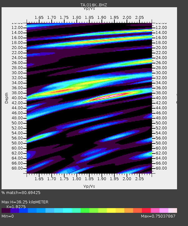
| Estimated Moho Depth: |
39.25 km |
| Estimated Crust Vp/Vs: |
1.93 |
| Assumed Crust Vp: |
6.24 km/s |
| Estimated Crust Vs: |
3.237 km/s |
| Estimated Crust Poisson's Ratio: |
0.32 |
|
| Radial Match: |
80.69425 % |
| Radial Bump: |
400 |
| Transverse Match: |
75.48649 % |
| Transverse Bump: |
400 |
| SOD ConfigId: |
19053131 |
| Insert Time: |
2019-08-12 20:48:15.698 +0000 |
| GWidth: |
2.5 |
| Max Bumps: |
400 |
| Tol: |
0.001 |
|

Signal To Noise
| Channel | StoN | STA | LTA |
| TA:O16K: :BHZ:20190729T20:45:45.599986Z | 5.9503794 | 4.2736218E-7 | 7.1821E-8 |
| TA:O16K: :BHN:20190729T20:45:45.599986Z | 1.4085813 | 6.442256E-8 | 4.5735778E-8 |
| TA:O16K: :BHE:20190729T20:45:45.599986Z | 4.6890326 | 2.5104356E-7 | 5.3538454E-8 |
| Arrivals |
| Ps | 6.1 SECOND |
| PpPs | 17 SECOND |
| PsPs/PpSs | 24 SECOND |


