You are here: Home > Network List > IW - Intermountain West Stations List
> Station PLID Pearl Lake, Idaho, USA > Earthquake Result Viewer
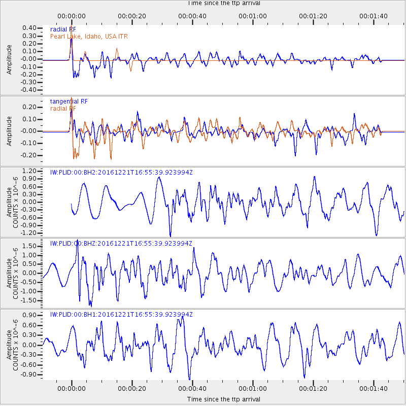
PLID Pearl Lake, Idaho, USA - Earthquake Result Viewer
*The percent match for this event was below the threshold and hence no stack was calculated.
| Earthquake location: |
Mariana Islands Region |
| Earthquake latitude/longitude: |
21.5/145.4 |
| Earthquake time(UTC): |
2016/12/21 (356) 16:43:58 GMT |
| Earthquake Depth: |
17 km |
| Earthquake Magnitude: |
5.9 Mwb |
| Earthquake Catalog/Contributor: |
NEIC PDE/us |
|
| Network: |
IW Intermountain West |
| Station: |
PLID Pearl Lake, Idaho, USA |
| Lat/Lon: |
45.09 N/116.00 W |
| Elevation: |
2164 m |
|
| Distance: |
80.9 deg |
| Az: |
45.185 deg |
| Baz: |
291.192 deg |
| Ray Param: |
$rayparam |
*The percent match for this event was below the threshold and hence was not used in the summary stack. |
|
| Radial Match: |
49.290356 % |
| Radial Bump: |
400 |
| Transverse Match: |
56.86867 % |
| Transverse Bump: |
400 |
| SOD ConfigId: |
1894071 |
| Insert Time: |
2017-01-04 16:46:41.602 +0000 |
| GWidth: |
2.5 |
| Max Bumps: |
400 |
| Tol: |
0.001 |
|
Signal To Noise
| Channel | StoN | STA | LTA |
| IW:PLID:00:BHZ:20161221T16:55:39.923994Z | 2.0030844 | 8.1962577E-7 | 4.0918184E-7 |
| IW:PLID:00:BH1:20161221T16:55:39.923994Z | 1.5367754 | 4.1571437E-7 | 2.7051084E-7 |
| IW:PLID:00:BH2:20161221T16:55:39.923994Z | 1.6715232 | 6.107016E-7 | 3.6535633E-7 |
| Arrivals |
| Ps | |
| PpPs | |
| PsPs/PpSs | |


