You are here: Home > Network List > TA - USArray Transportable Network (new EarthScope stations) Stations List
> Station R31K City Hall, Gustavus, AK, USA > Earthquake Result Viewer
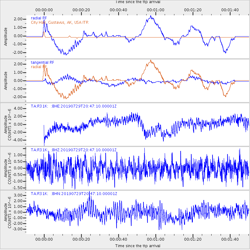
R31K City Hall, Gustavus, AK, USA - Earthquake Result Viewer
*The percent match for this event was below the threshold and hence no stack was calculated.
| Earthquake location: |
Southeast Of Honshu, Japan |
| Earthquake latitude/longitude: |
32.8/140.6 |
| Earthquake time(UTC): |
2019/07/29 (210) 20:37:42 GMT |
| Earthquake Depth: |
53 km |
| Earthquake Magnitude: |
5.7 Mww |
| Earthquake Catalog/Contributor: |
NEIC PDE/us |
|
| Network: |
TA USArray Transportable Network (new EarthScope stations) |
| Station: |
R31K City Hall, Gustavus, AK, USA |
| Lat/Lon: |
58.41 N/135.74 W |
| Elevation: |
15 m |
|
| Distance: |
59.5 deg |
| Az: |
37.387 deg |
| Baz: |
283.808 deg |
| Ray Param: |
$rayparam |
*The percent match for this event was below the threshold and hence was not used in the summary stack. |
|
| Radial Match: |
38.771564 % |
| Radial Bump: |
400 |
| Transverse Match: |
39.090885 % |
| Transverse Bump: |
400 |
| SOD ConfigId: |
19053131 |
| Insert Time: |
2019-08-12 20:48:29.125 +0000 |
| GWidth: |
2.5 |
| Max Bumps: |
400 |
| Tol: |
0.001 |
|
Signal To Noise
| Channel | StoN | STA | LTA |
| TA:R31K: :BHZ:20190729T20:47:10.00001Z | 1.5936313 | 6.365304E-7 | 3.994214E-7 |
| TA:R31K: :BHN:20190729T20:47:10.00001Z | 0.9725499 | 5.936686E-7 | 6.1042476E-7 |
| TA:R31K: :BHE:20190729T20:47:10.00001Z | 2.1102166 | 2.110718E-6 | 1.0002377E-6 |
| Arrivals |
| Ps | |
| PpPs | |
| PsPs/PpSs | |


