You are here: Home > Network List > TA - USArray Transportable Network (new EarthScope stations) Stations List
> Station E09A Wood Farm, Starbuck, WA, USA > Earthquake Result Viewer
E09A Wood Farm, Starbuck, WA, USA - Earthquake Result Viewer

| Earthquake location: |
South Of Mariana Islands |
| Earthquake latitude/longitude: |
10.5/145.7 |
| Earthquake time(UTC): |
2007/09/30 (273) 02:08:30 GMT |
| Earthquake Depth: |
14 km |
| Earthquake Magnitude: |
6.4 MB, 7.1 MS, 6.9 MW, 6.9 MW |
| Earthquake Catalog/Contributor: |
WHDF/NEIC |
|
| Network: |
TA USArray Transportable Network (new EarthScope stations) |
| Station: |
E09A Wood Farm, Starbuck, WA, USA |
| Lat/Lon: |
46.51 N/118.15 W |
| Elevation: |
304 m |
|
| Distance: |
86.7 deg |
| Az: |
43.456 deg |
| Baz: |
281.588 deg |
| Ray Param: |
0.04386255 |
| Estimated Moho Depth: |
32.25 km |
| Estimated Crust Vp/Vs: |
1.63 |
| Assumed Crust Vp: |
6.419 km/s |
| Estimated Crust Vs: |
3.938 km/s |
| Estimated Crust Poisson's Ratio: |
0.20 |
|
| Radial Match: |
92.14885 % |
| Radial Bump: |
367 |
| Transverse Match: |
80.517715 % |
| Transverse Bump: |
400 |
| SOD ConfigId: |
2564 |
| Insert Time: |
2010-03-07 02:26:48.653 +0000 |
| GWidth: |
2.5 |
| Max Bumps: |
400 |
| Tol: |
0.001 |
|
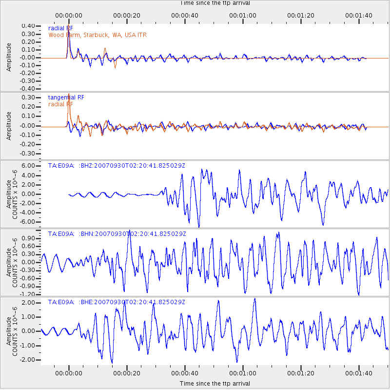
Signal To Noise
| Channel | StoN | STA | LTA |
| TA:E09A: :BHN:20070930T02:20:41.825029Z | 0.52833647 | 1.0297768E-7 | 1.9490926E-7 |
| TA:E09A: :BHE:20070930T02:20:41.825029Z | 1.0903109 | 2.520621E-7 | 2.311837E-7 |
| TA:E09A: :BHZ:20070930T02:20:41.825029Z | 2.8491642 | 8.431918E-7 | 2.9594355E-7 |
| Arrivals |
| Ps | 3.2 SECOND |
| PpPs | 13 SECOND |
| PsPs/PpSs | 16 SECOND |


