You are here: Home > Network List > TA - USArray Transportable Network (new EarthScope stations) Stations List
> Station E09A Wood Farm, Starbuck, WA, USA > Earthquake Result Viewer
E09A Wood Farm, Starbuck, WA, USA - Earthquake Result Viewer

| Earthquake location: |
Volcano Islands, Japan Region |
| Earthquake latitude/longitude: |
22.0/142.7 |
| Earthquake time(UTC): |
2007/09/28 (271) 13:38:59 GMT |
| Earthquake Depth: |
276 km |
| Earthquake Magnitude: |
6.7 MB, 7.4 MW, 7.4 MW |
| Earthquake Catalog/Contributor: |
WHDF/NEIC |
|
| Network: |
TA USArray Transportable Network (new EarthScope stations) |
| Station: |
E09A Wood Farm, Starbuck, WA, USA |
| Lat/Lon: |
46.51 N/118.15 W |
| Elevation: |
304 m |
|
| Distance: |
80.4 deg |
| Az: |
43.742 deg |
| Baz: |
291.703 deg |
| Ray Param: |
0.047590084 |
| Estimated Moho Depth: |
32.0 km |
| Estimated Crust Vp/Vs: |
1.60 |
| Assumed Crust Vp: |
6.419 km/s |
| Estimated Crust Vs: |
4.012 km/s |
| Estimated Crust Poisson's Ratio: |
0.18 |
|
| Radial Match: |
95.32805 % |
| Radial Bump: |
380 |
| Transverse Match: |
86.06799 % |
| Transverse Bump: |
400 |
| SOD ConfigId: |
2564 |
| Insert Time: |
2010-03-07 02:27:02.250 +0000 |
| GWidth: |
2.5 |
| Max Bumps: |
400 |
| Tol: |
0.001 |
|
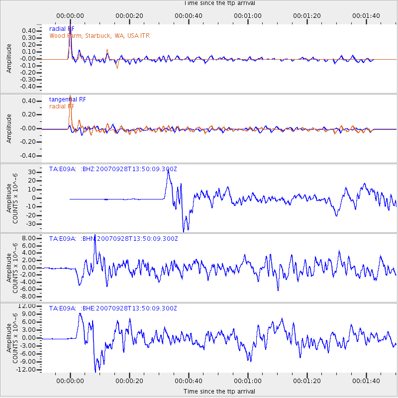
Signal To Noise
| Channel | StoN | STA | LTA |
| TA:E09A: :BHN:20070928T13:50:09.300Z | 19.793087 | 2.1116264E-6 | 1.0668504E-7 |
| TA:E09A: :BHE:20070928T13:50:09.300Z | 53.46142 | 4.5975685E-6 | 8.599788E-8 |
| TA:E09A: :BHZ:20070928T13:50:09.300Z | 81.32486 | 1.4498885E-5 | 1.7828356E-7 |
| Arrivals |
| Ps | 3.1 SECOND |
| PpPs | 13 SECOND |
| PsPs/PpSs | 16 SECOND |


