You are here: Home > Network List > TA - USArray Transportable Network (new EarthScope stations) Stations List
> Station E09A Wood Farm, Starbuck, WA, USA > Earthquake Result Viewer
E09A Wood Farm, Starbuck, WA, USA - Earthquake Result Viewer
| Earthquake location: |
Taiwan Region |
| Earthquake latitude/longitude: |
24.3/122.2 |
| Earthquake time(UTC): |
2007/09/06 (249) 17:51:26 GMT |
| Earthquake Depth: |
53 km |
| Earthquake Magnitude: |
6.1 MB, 6.2 MW, 6.1 ME |
| Earthquake Catalog/Contributor: |
WHDF/NEIC |
|
| Network: |
TA USArray Transportable Network (new EarthScope stations) |
| Station: |
E09A Wood Farm, Starbuck, WA, USA |
| Lat/Lon: |
46.51 N/118.15 W |
| Elevation: |
304 m |
|
| Distance: |
90.9 deg |
| Az: |
36.894 deg |
| Baz: |
307.541 deg |
| Ray Param: |
0.041634522 |
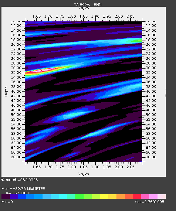
| Estimated Moho Depth: |
30.75 km |
| Estimated Crust Vp/Vs: |
1.67 |
| Assumed Crust Vp: |
6.419 km/s |
| Estimated Crust Vs: |
3.844 km/s |
| Estimated Crust Poisson's Ratio: |
0.22 |
|
| Radial Match: |
85.13825 % |
| Radial Bump: |
400 |
| Transverse Match: |
74.14623 % |
| Transverse Bump: |
400 |
| SOD ConfigId: |
2564 |
| Insert Time: |
2010-03-07 02:27:05.788 +0000 |
| GWidth: |
2.5 |
| Max Bumps: |
400 |
| Tol: |
0.001 |
|
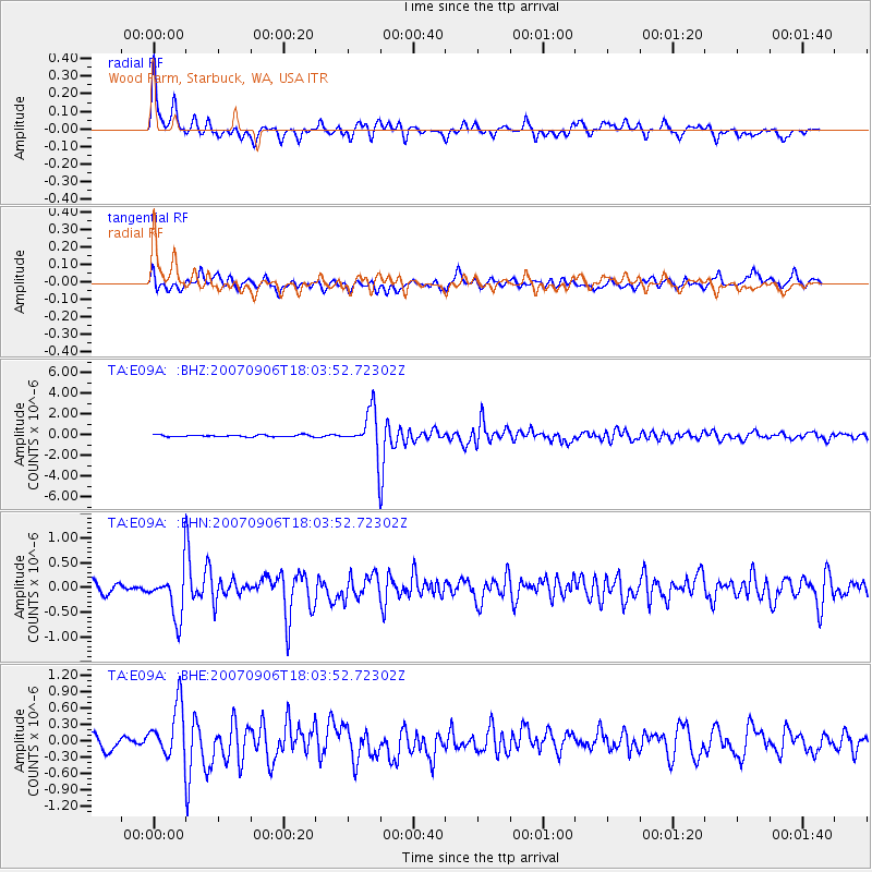
Signal To Noise
| Channel | StoN | STA | LTA |
| TA:E09A: :BHN:20070906T18:03:52.72302Z | 4.0020475 | 4.6779962E-7 | 1.16890064E-7 |
| TA:E09A: :BHE:20070906T18:03:52.72302Z | 3.4781468 | 4.791273E-7 | 1.3775362E-7 |
| TA:E09A: :BHZ:20070906T18:03:52.72302Z | 21.79811 | 2.060768E-6 | 9.453884E-8 |
| Arrivals |
| Ps | 3.3 SECOND |
| PpPs | 13 SECOND |
| PsPs/PpSs | 16 SECOND |


