You are here: Home > Network List > TA - USArray Transportable Network (new EarthScope stations) Stations List
> Station E09A Wood Farm, Starbuck, WA, USA > Earthquake Result Viewer
E09A Wood Farm, Starbuck, WA, USA - Earthquake Result Viewer
| Earthquake location: |
Solomon Islands |
| Earthquake latitude/longitude: |
-9.8/159.5 |
| Earthquake time(UTC): |
2007/08/16 (228) 08:39:27 GMT |
| Earthquake Depth: |
10 km |
| Earthquake Magnitude: |
6.1 MB, 6.7 MS, 6.4 MW |
| Earthquake Catalog/Contributor: |
WHDF/NEIC |
|
| Network: |
TA USArray Transportable Network (new EarthScope stations) |
| Station: |
E09A Wood Farm, Starbuck, WA, USA |
| Lat/Lon: |
46.51 N/118.15 W |
| Elevation: |
304 m |
|
| Distance: |
91.9 deg |
| Az: |
43.226 deg |
| Baz: |
257.78 deg |
| Ray Param: |
0.041545328 |
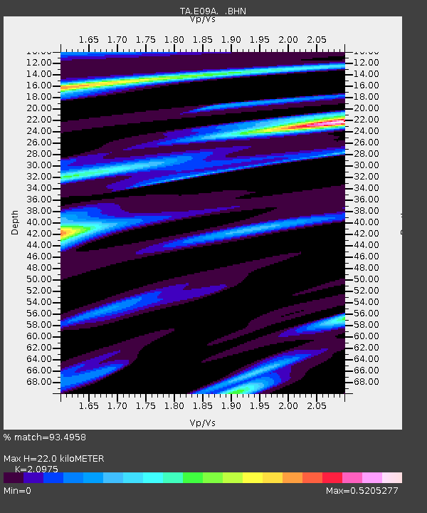
| Estimated Moho Depth: |
22.0 km |
| Estimated Crust Vp/Vs: |
2.10 |
| Assumed Crust Vp: |
6.419 km/s |
| Estimated Crust Vs: |
3.06 km/s |
| Estimated Crust Poisson's Ratio: |
0.35 |
|
| Radial Match: |
93.4958 % |
| Radial Bump: |
378 |
| Transverse Match: |
76.69885 % |
| Transverse Bump: |
400 |
| SOD ConfigId: |
2564 |
| Insert Time: |
2010-03-07 02:27:09.428 +0000 |
| GWidth: |
2.5 |
| Max Bumps: |
400 |
| Tol: |
0.001 |
|
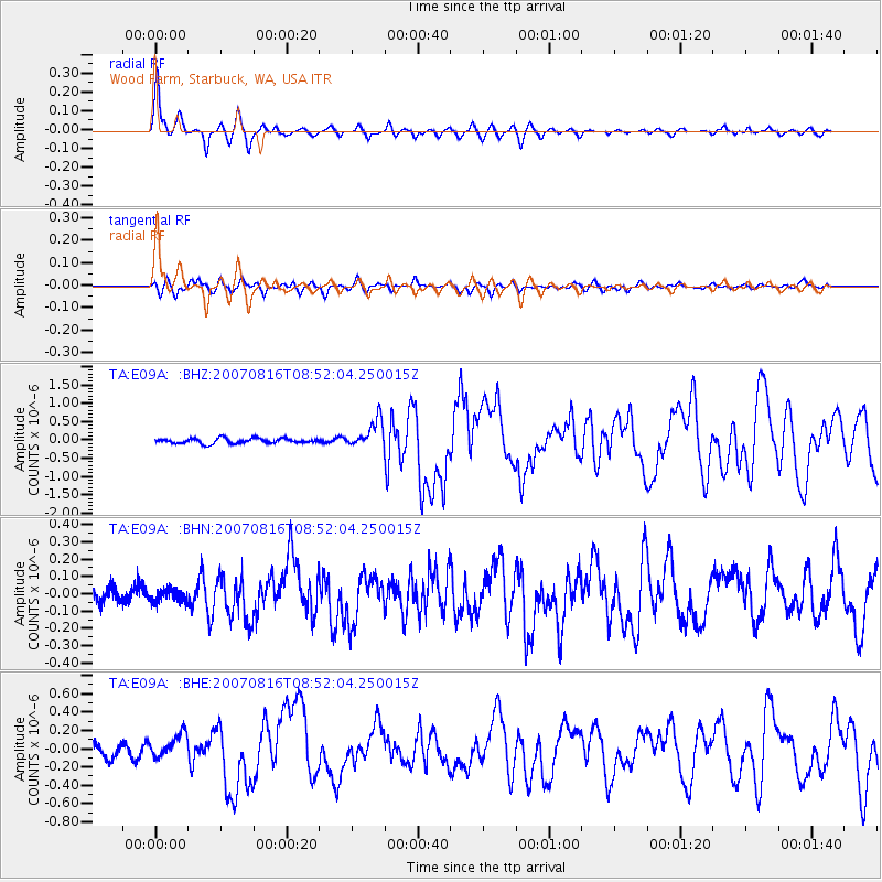
Signal To Noise
| Channel | StoN | STA | LTA |
| TA:E09A: :BHN:20070816T08:52:04.250015Z | 0.53312385 | 3.6015287E-8 | 6.75552E-8 |
| TA:E09A: :BHE:20070816T08:52:04.250015Z | 1.7303183 | 1.2155218E-7 | 7.024845E-8 |
| TA:E09A: :BHZ:20070816T08:52:04.250015Z | 5.4869785 | 3.713061E-7 | 6.767041E-8 |
| Arrivals |
| Ps | 3.8 SECOND |
| PpPs | 10 SECOND |
| PsPs/PpSs | 14 SECOND |


