You are here: Home > Network List > US - United States National Seismic Network Stations List
> Station DGMT Dagmar, Montana, USA > Earthquake Result Viewer
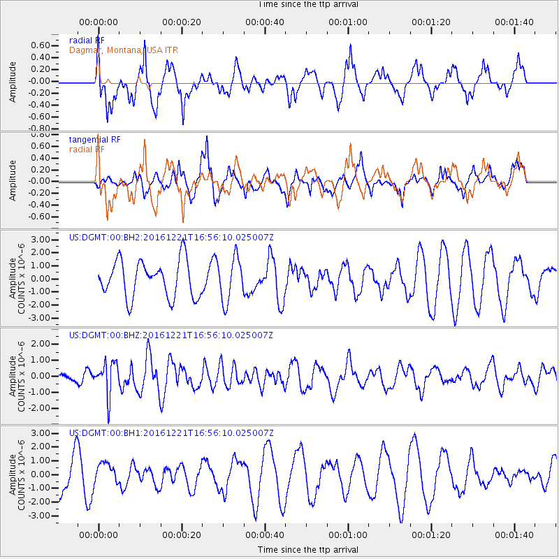
DGMT Dagmar, Montana, USA - Earthquake Result Viewer
*The percent match for this event was below the threshold and hence no stack was calculated.
| Earthquake location: |
Mariana Islands Region |
| Earthquake latitude/longitude: |
21.5/145.4 |
| Earthquake time(UTC): |
2016/12/21 (356) 16:43:58 GMT |
| Earthquake Depth: |
17 km |
| Earthquake Magnitude: |
5.9 Mwb |
| Earthquake Catalog/Contributor: |
NEIC PDE/us |
|
| Network: |
US United States National Seismic Network |
| Station: |
DGMT Dagmar, Montana, USA |
| Lat/Lon: |
48.47 N/104.20 W |
| Elevation: |
0.0 m |
|
| Distance: |
86.8 deg |
| Az: |
38.657 deg |
| Baz: |
299.082 deg |
| Ray Param: |
$rayparam |
*The percent match for this event was below the threshold and hence was not used in the summary stack. |
|
| Radial Match: |
66.4767 % |
| Radial Bump: |
400 |
| Transverse Match: |
64.111404 % |
| Transverse Bump: |
372 |
| SOD ConfigId: |
1894071 |
| Insert Time: |
2017-01-04 16:47:26.775 +0000 |
| GWidth: |
2.5 |
| Max Bumps: |
400 |
| Tol: |
0.001 |
|
Signal To Noise
| Channel | StoN | STA | LTA |
| US:DGMT:00:BHZ:20161221T16:56:10.025007Z | 2.93956 | 1.0591234E-6 | 3.6029996E-7 |
| US:DGMT:00:BH1:20161221T16:56:10.025007Z | 0.60973966 | 7.5222636E-7 | 1.2336844E-6 |
| US:DGMT:00:BH2:20161221T16:56:10.025007Z | 1.2069982 | 1.6973326E-6 | 1.4062429E-6 |
| Arrivals |
| Ps | |
| PpPs | |
| PsPs/PpSs | |


