You are here: Home > Network List > XV14 - Fault Locations and Alaska Tectonics from Seismicity Stations List
> Station FTGH Toghotthele, Parks Hwy, AK, USA > Earthquake Result Viewer
FTGH Toghotthele, Parks Hwy, AK, USA - Earthquake Result Viewer
| Earthquake location: |
Southeast Of Honshu, Japan |
| Earthquake latitude/longitude: |
32.8/140.6 |
| Earthquake time(UTC): |
2019/07/29 (210) 20:37:42 GMT |
| Earthquake Depth: |
53 km |
| Earthquake Magnitude: |
5.7 Mww |
| Earthquake Catalog/Contributor: |
NEIC PDE/us |
|
| Network: |
XV Fault Locations and Alaska Tectonics from Seismicity |
| Station: |
FTGH Toghotthele, Parks Hwy, AK, USA |
| Lat/Lon: |
64.69 N/148.83 W |
| Elevation: |
286 m |
|
| Distance: |
52.6 deg |
| Az: |
30.694 deg |
| Baz: |
268.542 deg |
| Ray Param: |
0.066527545 |
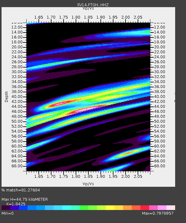
| Estimated Moho Depth: |
44.75 km |
| Estimated Crust Vp/Vs: |
1.84 |
| Assumed Crust Vp: |
6.566 km/s |
| Estimated Crust Vs: |
3.564 km/s |
| Estimated Crust Poisson's Ratio: |
0.29 |
|
| Radial Match: |
81.27684 % |
| Radial Bump: |
400 |
| Transverse Match: |
34.930958 % |
| Transverse Bump: |
400 |
| SOD ConfigId: |
19053131 |
| Insert Time: |
2019-08-12 20:50:46.961 +0000 |
| GWidth: |
2.5 |
| Max Bumps: |
400 |
| Tol: |
0.001 |
|

Signal To Noise
| Channel | StoN | STA | LTA |
| XV:FTGH: :HHZ:20190729T20:46:20.779979Z | 10.121799 | 5.8053286E-7 | 5.7354708E-8 |
| XV:FTGH: :HHN:20190729T20:46:20.779979Z | 2.1142173 | 2.232635E-7 | 1.0560101E-7 |
| XV:FTGH: :HHE:20190729T20:46:20.779979Z | 4.6826763 | 2.8891063E-7 | 6.1697754E-8 |
| Arrivals |
| Ps | 6.1 SECOND |
| PpPs | 18 SECOND |
| PsPs/PpSs | 24 SECOND |


