You are here: Home > Network List > TA - USArray Transportable Network (new EarthScope stations) Stations List
> Station E09A Wood Farm, Starbuck, WA, USA > Earthquake Result Viewer
E09A Wood Farm, Starbuck, WA, USA - Earthquake Result Viewer
| Earthquake location: |
South Of Panama |
| Earthquake latitude/longitude: |
4.6/-78.5 |
| Earthquake time(UTC): |
2007/03/18 (077) 02:11:05 GMT |
| Earthquake Depth: |
8.0 km |
| Earthquake Magnitude: |
6.4 MB, 5.7 MS, 6.2 MW, 6.1 MW |
| Earthquake Catalog/Contributor: |
WHDF/NEIC |
|
| Network: |
TA USArray Transportable Network (new EarthScope stations) |
| Station: |
E09A Wood Farm, Starbuck, WA, USA |
| Lat/Lon: |
46.51 N/118.15 W |
| Elevation: |
304 m |
|
| Distance: |
54.0 deg |
| Az: |
327.009 deg |
| Baz: |
128.191 deg |
| Ray Param: |
0.06571642 |
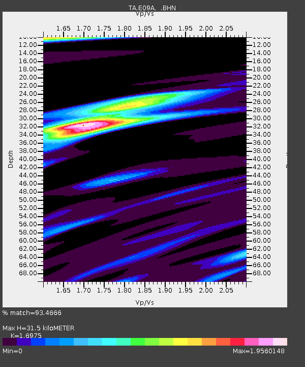
| Estimated Moho Depth: |
31.5 km |
| Estimated Crust Vp/Vs: |
1.70 |
| Assumed Crust Vp: |
6.419 km/s |
| Estimated Crust Vs: |
3.782 km/s |
| Estimated Crust Poisson's Ratio: |
0.23 |
|
| Radial Match: |
93.4666 % |
| Radial Bump: |
394 |
| Transverse Match: |
80.61774 % |
| Transverse Bump: |
400 |
| SOD ConfigId: |
2564 |
| Insert Time: |
2010-03-07 02:27:52.192 +0000 |
| GWidth: |
2.5 |
| Max Bumps: |
400 |
| Tol: |
0.001 |
|
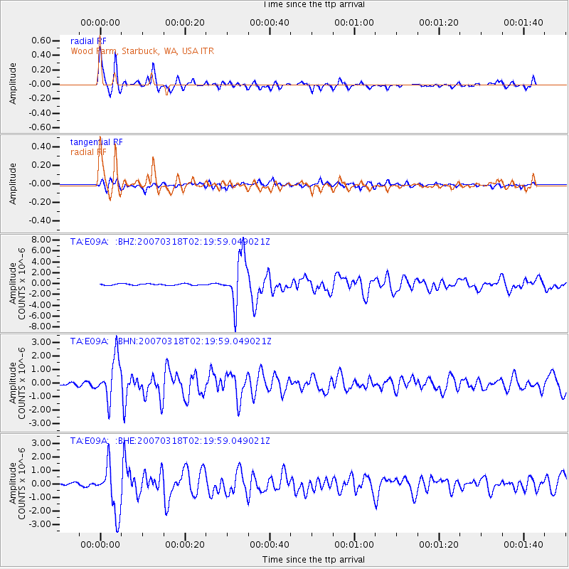
Signal To Noise
| Channel | StoN | STA | LTA |
| TA:E09A: :BHN:20070318T02:19:59.049021Z | 10.080215 | 1.566481E-6 | 1.5540154E-7 |
| TA:E09A: :BHE:20070318T02:19:59.049021Z | 22.584177 | 1.8223477E-6 | 8.069135E-8 |
| TA:E09A: :BHZ:20070318T02:19:59.049021Z | 32.84424 | 4.5335323E-6 | 1.380313E-7 |
| Arrivals |
| Ps | 3.6 SECOND |
| PpPs | 13 SECOND |
| PsPs/PpSs | 16 SECOND |


