You are here: Home > Network List > AK - Alaska Regional Network Stations List
> Station KTH Kantishna Hills > Earthquake Result Viewer
KTH Kantishna Hills - Earthquake Result Viewer
| Earthquake location: |
El Salvador |
| Earthquake latitude/longitude: |
13.3/-89.3 |
| Earthquake time(UTC): |
2019/07/31 (212) 05:54:55 GMT |
| Earthquake Depth: |
72 km |
| Earthquake Magnitude: |
5.9 Mww |
| Earthquake Catalog/Contributor: |
NEIC PDE/us |
|
| Network: |
AK Alaska Regional Network |
| Station: |
KTH Kantishna Hills |
| Lat/Lon: |
63.55 N/150.92 W |
| Elevation: |
1172 m |
|
| Distance: |
65.7 deg |
| Az: |
334.401 deg |
| Baz: |
110.031 deg |
| Ray Param: |
0.05791692 |
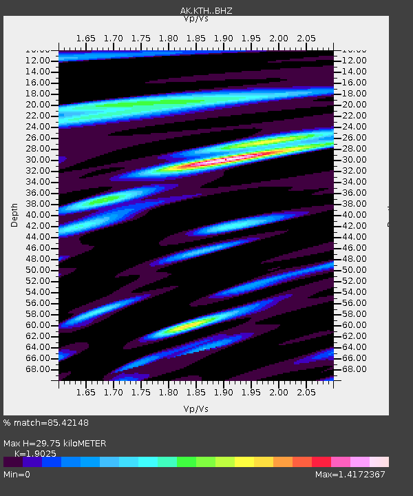
| Estimated Moho Depth: |
29.75 km |
| Estimated Crust Vp/Vs: |
1.90 |
| Assumed Crust Vp: |
6.438 km/s |
| Estimated Crust Vs: |
3.384 km/s |
| Estimated Crust Poisson's Ratio: |
0.31 |
|
| Radial Match: |
85.42148 % |
| Radial Bump: |
400 |
| Transverse Match: |
67.156044 % |
| Transverse Bump: |
400 |
| SOD ConfigId: |
19053131 |
| Insert Time: |
2019-08-14 05:57:35.084 +0000 |
| GWidth: |
2.5 |
| Max Bumps: |
400 |
| Tol: |
0.001 |
|

Signal To Noise
| Channel | StoN | STA | LTA |
| AK:KTH: :BHZ:20190731T06:05:01.468016Z | 4.3739095 | 2.004617E-7 | 4.5831243E-8 |
| AK:KTH: :BHN:20190731T06:05:01.468016Z | 2.955136 | 1.209281E-7 | 4.0921336E-8 |
| AK:KTH: :BHE:20190731T06:05:01.468016Z | 2.15312 | 8.230146E-8 | 3.8224282E-8 |
| Arrivals |
| Ps | 4.3 SECOND |
| PpPs | 13 SECOND |
| PsPs/PpSs | 17 SECOND |


