You are here: Home > Network List > TA - USArray Transportable Network (new EarthScope stations) Stations List
> Station R04C Big Horse Ranch, Ione, CA, USA > Earthquake Result Viewer
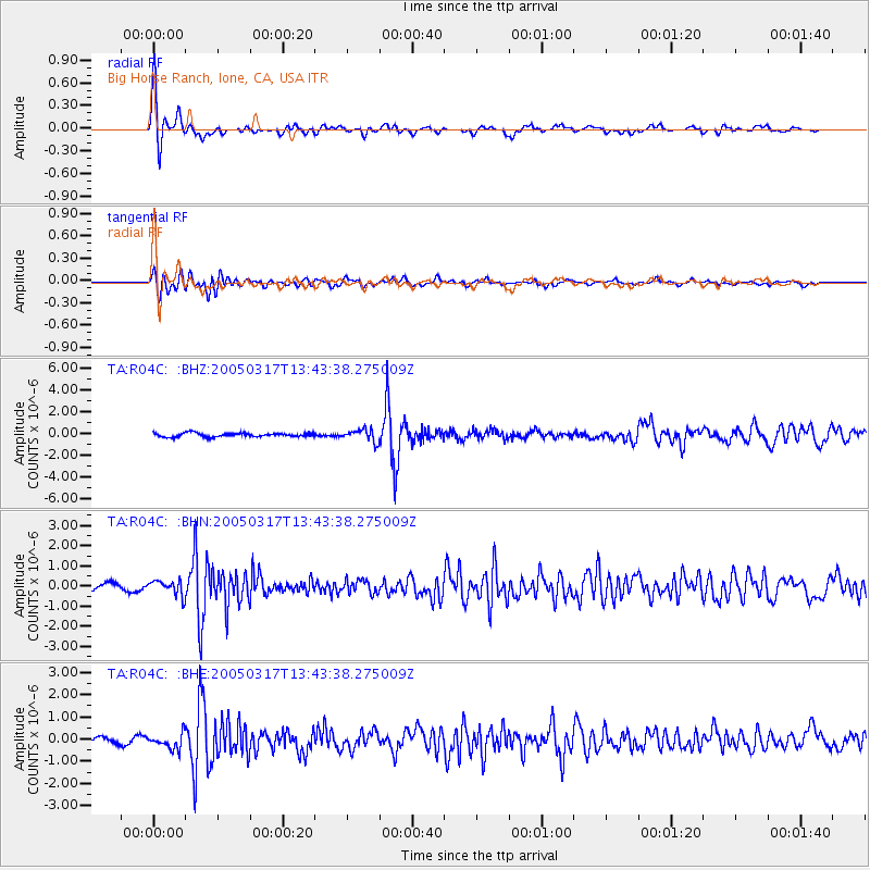
R04C Big Horse Ranch, Ione, CA, USA - Earthquake Result Viewer
| Earthquake location: |
Mexico-Guatemala Border Region |
| Earthquake latitude/longitude: |
15.1/-91.4 |
| Earthquake time(UTC): |
2005/03/17 (076) 13:37:37 GMT |
| Earthquake Depth: |
197 km |
| Earthquake Magnitude: |
5.5 MB, 6.2 MW, 6.2 MW |
| Earthquake Catalog/Contributor: |
WHDF/NEIC |
|
| Network: |
TA USArray Transportable Network (new EarthScope stations) |
| Station: |
R04C Big Horse Ranch, Ione, CA, USA |
| Lat/Lon: |
38.26 N/120.94 W |
| Elevation: |
115 m |
|
| Distance: |
34.8 deg |
| Az: |
317.087 deg |
| Baz: |
123.36 deg |
| Ray Param: |
0.076855764 |
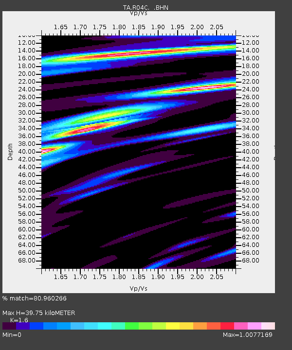
| Estimated Moho Depth: |
39.75 km |
| Estimated Crust Vp/Vs: |
1.60 |
| Assumed Crust Vp: |
6.597 km/s |
| Estimated Crust Vs: |
4.123 km/s |
| Estimated Crust Poisson's Ratio: |
0.18 |
|
| Radial Match: |
80.960266 % |
| Radial Bump: |
400 |
| Transverse Match: |
68.91776 % |
| Transverse Bump: |
400 |
| SOD ConfigId: |
2455 |
| Insert Time: |
2010-03-07 02:27:57.107 +0000 |
| GWidth: |
2.5 |
| Max Bumps: |
400 |
| Tol: |
0.001 |
|
Signal To Noise
| Channel | StoN | STA | LTA |
| TA:R04C: :BHN:20050317T13:43:38.275009Z | 2.3526337 | 3.7787117E-7 | 1.6061624E-7 |
| TA:R04C: :BHE:20050317T13:43:38.275009Z | 2.403545 | 3.3764954E-7 | 1.404798E-7 |
| TA:R04C: :BHZ:20050317T13:43:38.275009Z | 3.095629 | 5.573592E-7 | 1.8004715E-7 |
| Arrivals |
| Ps | 4.0 SECOND |
| PpPs | 14 SECOND |
| PsPs/PpSs | 18 SECOND |


