You are here: Home > Network List > AV - Alaska Volcano Observatory Stations List
> Station SPU Mount Spurr, Mount Spurr, Alaska > Earthquake Result Viewer
SPU Mount Spurr, Mount Spurr, Alaska - Earthquake Result Viewer
| Earthquake location: |
El Salvador |
| Earthquake latitude/longitude: |
13.3/-89.3 |
| Earthquake time(UTC): |
2019/07/31 (212) 05:54:55 GMT |
| Earthquake Depth: |
72 km |
| Earthquake Magnitude: |
5.9 Mww |
| Earthquake Catalog/Contributor: |
NEIC PDE/us |
|
| Network: |
AV Alaska Volcano Observatory |
| Station: |
SPU Mount Spurr, Mount Spurr, Alaska |
| Lat/Lon: |
61.18 N/152.06 W |
| Elevation: |
800 m |
|
| Distance: |
65.4 deg |
| Az: |
331.739 deg |
| Baz: |
107.925 deg |
| Ray Param: |
0.058095835 |
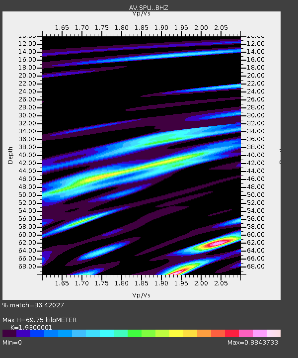
| Estimated Moho Depth: |
69.75 km |
| Estimated Crust Vp/Vs: |
1.93 |
| Assumed Crust Vp: |
6.566 km/s |
| Estimated Crust Vs: |
3.402 km/s |
| Estimated Crust Poisson's Ratio: |
0.32 |
|
| Radial Match: |
86.42027 % |
| Radial Bump: |
400 |
| Transverse Match: |
74.989105 % |
| Transverse Bump: |
400 |
| SOD ConfigId: |
19053131 |
| Insert Time: |
2019-08-14 05:58:12.820 +0000 |
| GWidth: |
2.5 |
| Max Bumps: |
400 |
| Tol: |
0.001 |
|
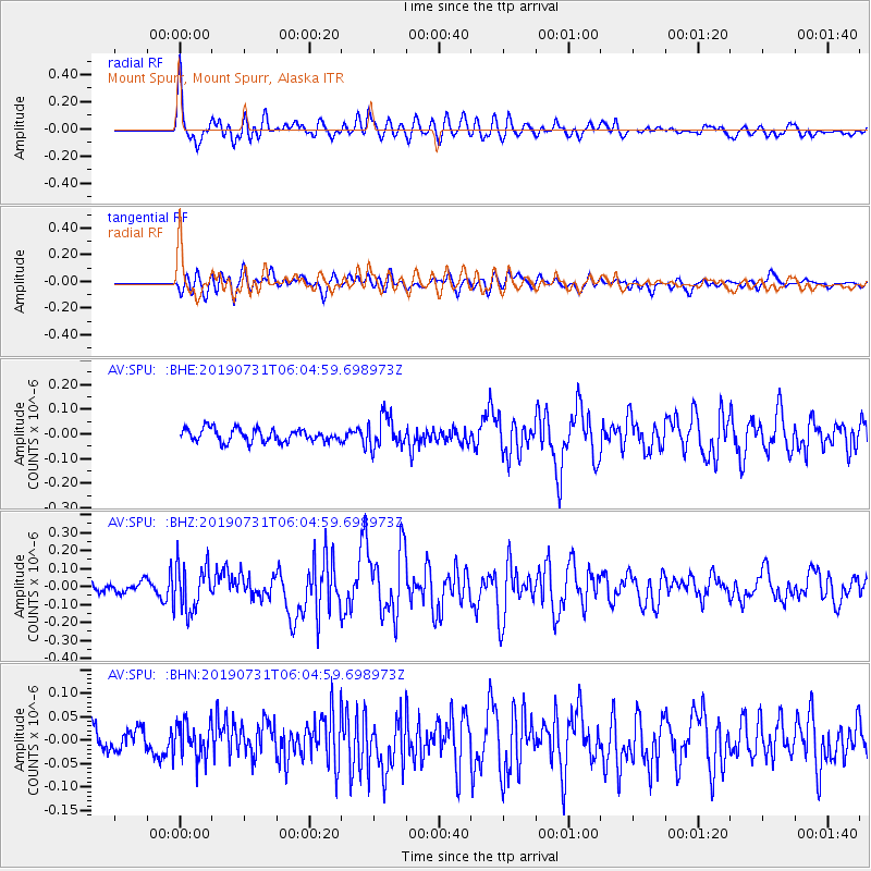
Signal To Noise
| Channel | StoN | STA | LTA |
| AV:SPU: :BHZ:20190731T06:04:59.698973Z | 3.7261448 | 1.2962676E-7 | 3.478844E-8 |
| AV:SPU: :BHN:20190731T06:04:59.698973Z | 1.275465 | 3.9748993E-8 | 3.1164316E-8 |
| AV:SPU: :BHE:20190731T06:04:59.698973Z | 2.388907 | 6.263201E-8 | 2.6217853E-8 |
| Arrivals |
| Ps | 10 SECOND |
| PpPs | 30 SECOND |
| PsPs/PpSs | 40 SECOND |


