You are here: Home > Network List > TA - USArray Transportable Network (new EarthScope stations) Stations List
> Station R04C Big Horse Ranch, Ione, CA, USA > Earthquake Result Viewer
R04C Big Horse Ranch, Ione, CA, USA - Earthquake Result Viewer
| Earthquake location: |
Bonin Islands, Japan Region |
| Earthquake latitude/longitude: |
26.1/144.0 |
| Earthquake time(UTC): |
2005/02/09 (040) 18:46:09 GMT |
| Earthquake Depth: |
24 km |
| Earthquake Magnitude: |
6.2 MB, 6.3 MS, 6.3 MW, 6.3 MW |
| Earthquake Catalog/Contributor: |
WHDF/NEIC |
|
| Network: |
TA USArray Transportable Network (new EarthScope stations) |
| Station: |
R04C Big Horse Ranch, Ione, CA, USA |
| Lat/Lon: |
38.26 N/120.94 W |
| Elevation: |
115 m |
|
| Distance: |
78.0 deg |
| Az: |
53.28 deg |
| Baz: |
293.705 deg |
| Ray Param: |
0.04988304 |
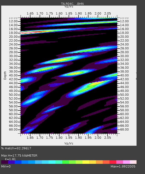
| Estimated Moho Depth: |
17.75 km |
| Estimated Crust Vp/Vs: |
1.61 |
| Assumed Crust Vp: |
6.597 km/s |
| Estimated Crust Vs: |
4.098 km/s |
| Estimated Crust Poisson's Ratio: |
0.19 |
|
| Radial Match: |
82.29617 % |
| Radial Bump: |
400 |
| Transverse Match: |
64.91988 % |
| Transverse Bump: |
400 |
| SOD ConfigId: |
5233 |
| Insert Time: |
2010-03-07 02:28:05.425 +0000 |
| GWidth: |
2.5 |
| Max Bumps: |
400 |
| Tol: |
0.001 |
|
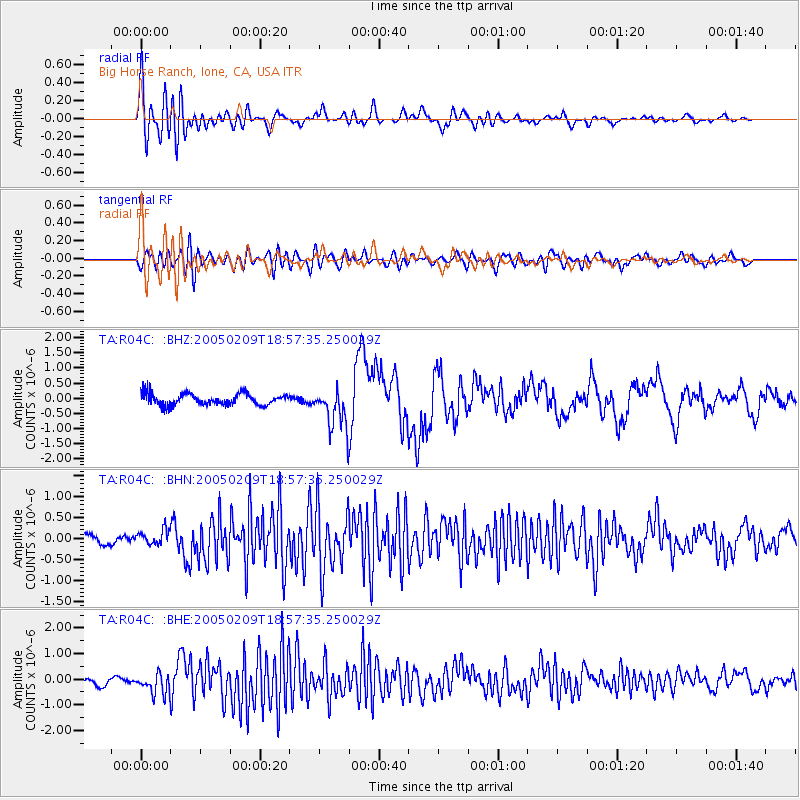
Signal To Noise
| Channel | StoN | STA | LTA |
| TA:R04C: :BHN:20050209T18:57:35.250029Z | 1.3805948 | 1.8999766E-7 | 1.3762015E-7 |
| TA:R04C: :BHE:20050209T18:57:35.250029Z | 3.5769904 | 3.8828102E-7 | 1.0854964E-7 |
| TA:R04C: :BHZ:20050209T18:57:35.250029Z | 3.4880226 | 6.6114296E-7 | 1.8954665E-7 |
| Arrivals |
| Ps | 1.7 SECOND |
| PpPs | 6.8 SECOND |
| PsPs/PpSs | 8.5 SECOND |


