You are here: Home > Network List > TA - USArray Transportable Network (new EarthScope stations) Stations List
> Station R04C Big Horse Ranch, Ione, CA, USA > Earthquake Result Viewer
R04C Big Horse Ranch, Ione, CA, USA - Earthquake Result Viewer
| Earthquake location: |
W. Caroline Islands, Micronesia |
| Earthquake latitude/longitude: |
10.9/140.8 |
| Earthquake time(UTC): |
2005/01/16 (016) 20:17:52 GMT |
| Earthquake Depth: |
25 km |
| Earthquake Magnitude: |
6.3 MB, 6.7 MS, 6.6 MW, 6.6 MW |
| Earthquake Catalog/Contributor: |
WHDF/NEIC |
|
| Network: |
TA USArray Transportable Network (new EarthScope stations) |
| Station: |
R04C Big Horse Ranch, Ione, CA, USA |
| Lat/Lon: |
38.26 N/120.94 W |
| Elevation: |
115 m |
|
| Distance: |
89.7 deg |
| Az: |
51.185 deg |
| Baz: |
283.59 deg |
| Ray Param: |
0.04172515 |
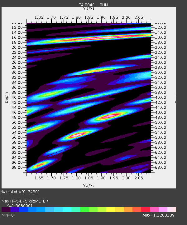
| Estimated Moho Depth: |
54.75 km |
| Estimated Crust Vp/Vs: |
1.81 |
| Assumed Crust Vp: |
6.597 km/s |
| Estimated Crust Vs: |
3.655 km/s |
| Estimated Crust Poisson's Ratio: |
0.28 |
|
| Radial Match: |
91.74891 % |
| Radial Bump: |
400 |
| Transverse Match: |
72.84162 % |
| Transverse Bump: |
400 |
| SOD ConfigId: |
5233 |
| Insert Time: |
2010-03-07 02:28:11.534 +0000 |
| GWidth: |
2.5 |
| Max Bumps: |
400 |
| Tol: |
0.001 |
|
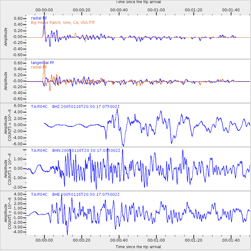
Signal To Noise
| Channel | StoN | STA | LTA |
| TA:R04C: :BHN:20050116T20:30:17.075002Z | 1.2485521 | 1.9994273E-7 | 1.6013969E-7 |
| TA:R04C: :BHE:20050116T20:30:17.075002Z | 4.582499 | 7.8568746E-7 | 1.7145393E-7 |
| TA:R04C: :BHZ:20050116T20:30:17.075002Z | 4.259847 | 1.2990469E-6 | 3.0495153E-7 |
| Arrivals |
| Ps | 6.8 SECOND |
| PpPs | 23 SECOND |
| PsPs/PpSs | 30 SECOND |


