You are here: Home > Network List > TA - USArray Transportable Network (new EarthScope stations) Stations List
> Station R04C Big Horse Ranch, Ione, CA, USA > Earthquake Result Viewer
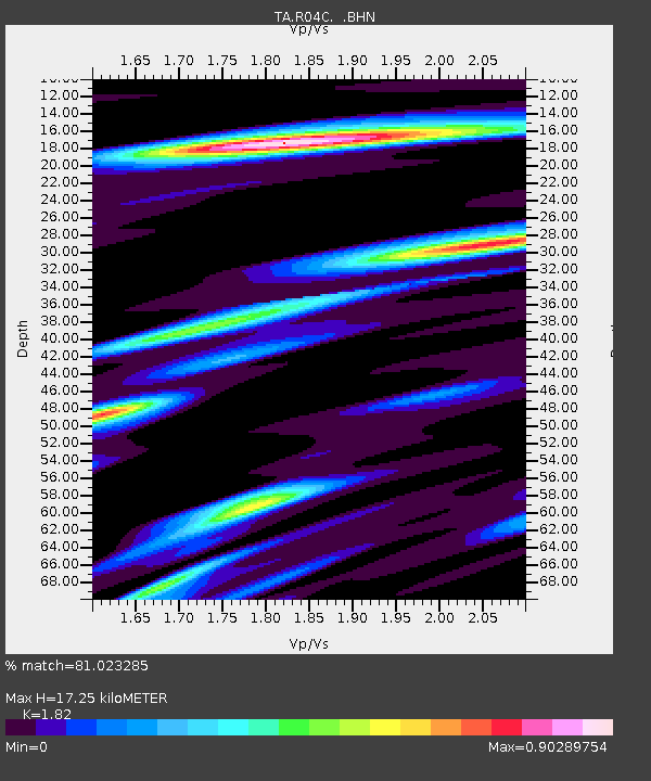
R04C Big Horse Ranch, Ione, CA, USA - Earthquake Result Viewer
| Earthquake location: |
Southeast Of Loyalty Islands |
| Earthquake latitude/longitude: |
-21.2/169.2 |
| Earthquake time(UTC): |
2007/10/13 (286) 17:45:53 GMT |
| Earthquake Depth: |
37 km |
| Earthquake Magnitude: |
5.8 MB, 5.9 MS, 6.1 MW, 6.1 MW |
| Earthquake Catalog/Contributor: |
WHDF/NEIC |
|
| Network: |
TA USArray Transportable Network (new EarthScope stations) |
| Station: |
R04C Big Horse Ranch, Ione, CA, USA |
| Lat/Lon: |
38.26 N/120.94 W |
| Elevation: |
115 m |
|
| Distance: |
88.2 deg |
| Az: |
47.69 deg |
| Baz: |
241.208 deg |
| Ray Param: |
0.04268595 |
| Estimated Moho Depth: |
17.25 km |
| Estimated Crust Vp/Vs: |
1.82 |
| Assumed Crust Vp: |
6.597 km/s |
| Estimated Crust Vs: |
3.625 km/s |
| Estimated Crust Poisson's Ratio: |
0.28 |
|
| Radial Match: |
81.023285 % |
| Radial Bump: |
400 |
| Transverse Match: |
80.08045 % |
| Transverse Bump: |
400 |
| SOD ConfigId: |
2564 |
| Insert Time: |
2010-03-07 02:29:37.012 +0000 |
| GWidth: |
2.5 |
| Max Bumps: |
400 |
| Tol: |
0.001 |
|

Signal To Noise
| Channel | StoN | STA | LTA |
| TA:R04C: :BHN:20071013T17:58:09.32502Z | 1.294292 | 1.6614416E-7 | 1.2836684E-7 |
| TA:R04C: :BHE:20071013T17:58:09.32502Z | 2.0791082 | 3.122937E-7 | 1.5020561E-7 |
| TA:R04C: :BHZ:20071013T17:58:09.32502Z | 3.476409 | 5.044129E-7 | 1.4509597E-7 |
| Arrivals |
| Ps | 2.2 SECOND |
| PpPs | 7.2 SECOND |
| PsPs/PpSs | 9.4 SECOND |


