You are here: Home > Network List > TA - USArray Transportable Network (new EarthScope stations) Stations List
> Station R04C Big Horse Ranch, Ione, CA, USA > Earthquake Result Viewer
R04C Big Horse Ranch, Ione, CA, USA - Earthquake Result Viewer
| Earthquake location: |
Kuril Islands |
| Earthquake latitude/longitude: |
46.5/153.2 |
| Earthquake time(UTC): |
2006/10/01 (274) 09:06:02 GMT |
| Earthquake Depth: |
19 km |
| Earthquake Magnitude: |
6.1 MB, 6.4 MS, 6.6 MW, 6.5 MW |
| Earthquake Catalog/Contributor: |
WHDF/NEIC |
|
| Network: |
TA USArray Transportable Network (new EarthScope stations) |
| Station: |
R04C Big Horse Ranch, Ione, CA, USA |
| Lat/Lon: |
38.26 N/120.94 W |
| Elevation: |
115 m |
|
| Distance: |
61.0 deg |
| Az: |
63.894 deg |
| Baz: |
307.967 deg |
| Ray Param: |
0.061159834 |
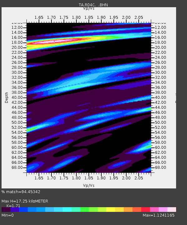
| Estimated Moho Depth: |
17.25 km |
| Estimated Crust Vp/Vs: |
1.71 |
| Assumed Crust Vp: |
6.597 km/s |
| Estimated Crust Vs: |
3.858 km/s |
| Estimated Crust Poisson's Ratio: |
0.24 |
|
| Radial Match: |
94.45342 % |
| Radial Bump: |
400 |
| Transverse Match: |
75.57548 % |
| Transverse Bump: |
400 |
| SOD ConfigId: |
2665 |
| Insert Time: |
2010-03-07 02:30:26.277 +0000 |
| GWidth: |
2.5 |
| Max Bumps: |
400 |
| Tol: |
0.001 |
|

Signal To Noise
| Channel | StoN | STA | LTA |
| TA:R04C: :BHN:20061001T09:15:43.150017Z | 2.4106266 | 3.0266128E-7 | 1.2555294E-7 |
| TA:R04C: :BHE:20061001T09:15:43.150017Z | 4.928712 | 4.543464E-7 | 9.2183605E-8 |
| TA:R04C: :BHZ:20061001T09:15:43.150017Z | 6.9457593 | 7.978949E-7 | 1.1487512E-7 |
| Arrivals |
| Ps | 2.0 SECOND |
| PpPs | 6.7 SECOND |
| PsPs/PpSs | 8.7 SECOND |


