You are here: Home > Network List > TA - USArray Transportable Network (new EarthScope stations) Stations List
> Station J20K Nowitna River, AK, USA > Earthquake Result Viewer
J20K Nowitna River, AK, USA - Earthquake Result Viewer

| Earthquake location: |
El Salvador |
| Earthquake latitude/longitude: |
13.3/-89.3 |
| Earthquake time(UTC): |
2019/07/31 (212) 05:54:55 GMT |
| Earthquake Depth: |
72 km |
| Earthquake Magnitude: |
5.9 Mww |
| Earthquake Catalog/Contributor: |
NEIC PDE/us |
|
| Network: |
TA USArray Transportable Network (new EarthScope stations) |
| Station: |
J20K Nowitna River, AK, USA |
| Lat/Lon: |
64.18 N/154.15 W |
| Elevation: |
314 m |
|
| Distance: |
67.3 deg |
| Az: |
334.551 deg |
| Baz: |
107.198 deg |
| Ray Param: |
0.056898866 |
| Estimated Moho Depth: |
34.5 km |
| Estimated Crust Vp/Vs: |
1.79 |
| Assumed Crust Vp: |
6.566 km/s |
| Estimated Crust Vs: |
3.668 km/s |
| Estimated Crust Poisson's Ratio: |
0.27 |
|
| Radial Match: |
88.48299 % |
| Radial Bump: |
400 |
| Transverse Match: |
78.244156 % |
| Transverse Bump: |
400 |
| SOD ConfigId: |
19053131 |
| Insert Time: |
2019-08-14 06:04:32.552 +0000 |
| GWidth: |
2.5 |
| Max Bumps: |
400 |
| Tol: |
0.001 |
|
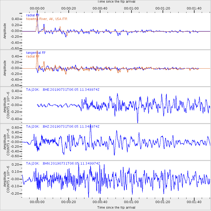
Signal To Noise
| Channel | StoN | STA | LTA |
| TA:J20K: :BHZ:20190731T06:05:11.349974Z | 4.646801 | 1.8084164E-7 | 3.891745E-8 |
| TA:J20K: :BHN:20190731T06:05:11.349974Z | 1.9702508 | 6.5284354E-8 | 3.313505E-8 |
| TA:J20K: :BHE:20190731T06:05:11.349974Z | 3.2962418 | 8.641739E-8 | 2.6216945E-8 |
| Arrivals |
| Ps | 4.3 SECOND |
| PpPs | 14 SECOND |
| PsPs/PpSs | 18 SECOND |


