You are here: Home > Network List > TA - USArray Transportable Network (new EarthScope stations) Stations List
> Station J26L Joseph Creek, AK, USA > Earthquake Result Viewer
J26L Joseph Creek, AK, USA - Earthquake Result Viewer

| Earthquake location: |
El Salvador |
| Earthquake latitude/longitude: |
13.3/-89.3 |
| Earthquake time(UTC): |
2019/07/31 (212) 05:54:55 GMT |
| Earthquake Depth: |
72 km |
| Earthquake Magnitude: |
5.9 Mww |
| Earthquake Catalog/Contributor: |
NEIC PDE/us |
|
| Network: |
TA USArray Transportable Network (new EarthScope stations) |
| Station: |
J26L Joseph Creek, AK, USA |
| Lat/Lon: |
64.50 N/143.56 W |
| Elevation: |
1144 m |
|
| Distance: |
63.1 deg |
| Az: |
336.816 deg |
| Baz: |
117.681 deg |
| Ray Param: |
0.059594505 |
| Estimated Moho Depth: |
38.25 km |
| Estimated Crust Vp/Vs: |
1.72 |
| Assumed Crust Vp: |
6.566 km/s |
| Estimated Crust Vs: |
3.823 km/s |
| Estimated Crust Poisson's Ratio: |
0.24 |
|
| Radial Match: |
87.94377 % |
| Radial Bump: |
400 |
| Transverse Match: |
63.530956 % |
| Transverse Bump: |
400 |
| SOD ConfigId: |
19053131 |
| Insert Time: |
2019-08-14 06:04:33.143 +0000 |
| GWidth: |
2.5 |
| Max Bumps: |
400 |
| Tol: |
0.001 |
|
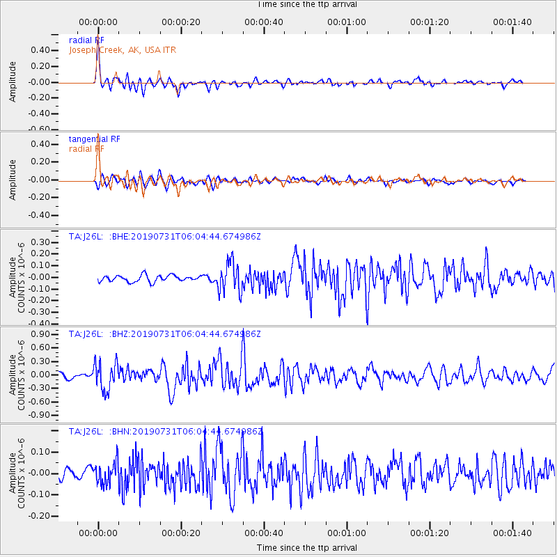
Signal To Noise
| Channel | StoN | STA | LTA |
| TA:J26L: :BHZ:20190731T06:04:44.674986Z | 4.3928576 | 3.1643788E-7 | 7.203463E-8 |
| TA:J26L: :BHN:20190731T06:04:44.674986Z | 1.2655745 | 5.1808147E-8 | 4.0936467E-8 |
| TA:J26L: :BHE:20190731T06:04:44.674986Z | 4.785824 | 1.3087622E-7 | 2.7346642E-8 |
| Arrivals |
| Ps | 4.4 SECOND |
| PpPs | 15 SECOND |
| PsPs/PpSs | 19 SECOND |


