You are here: Home > Network List > TA - USArray Transportable Network (new EarthScope stations) Stations List
> Station Q17K Contact Creek, Katmai, AK, USA > Earthquake Result Viewer
Q17K Contact Creek, Katmai, AK, USA - Earthquake Result Viewer
| Earthquake location: |
El Salvador |
| Earthquake latitude/longitude: |
13.3/-89.3 |
| Earthquake time(UTC): |
2019/07/31 (212) 05:54:55 GMT |
| Earthquake Depth: |
72 km |
| Earthquake Magnitude: |
5.9 Mww |
| Earthquake Catalog/Contributor: |
NEIC PDE/us |
|
| Network: |
TA USArray Transportable Network (new EarthScope stations) |
| Station: |
Q17K Contact Creek, Katmai, AK, USA |
| Lat/Lon: |
58.26 N/155.89 W |
| Elevation: |
1165 m |
|
| Distance: |
66.5 deg |
| Az: |
328.084 deg |
| Baz: |
103.133 deg |
| Ray Param: |
0.057383217 |
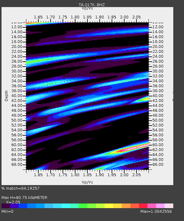
| Estimated Moho Depth: |
60.75 km |
| Estimated Crust Vp/Vs: |
2.05 |
| Assumed Crust Vp: |
6.438 km/s |
| Estimated Crust Vs: |
3.141 km/s |
| Estimated Crust Poisson's Ratio: |
0.34 |
|
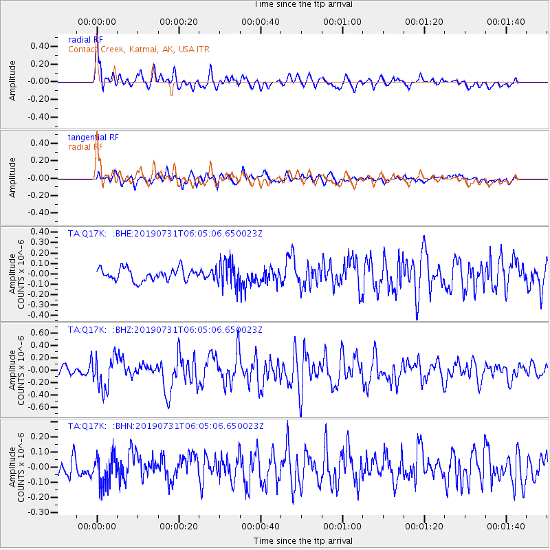
| Radial Match: |
84.19257 % |
| Radial Bump: |
400 |
| Transverse Match: |
64.6873 % |
| Transverse Bump: |
400 |
| SOD ConfigId: |
19053131 |
| Insert Time: |
2019-08-14 06:05:07.722 +0000 |
| GWidth: |
2.5 |
| Max Bumps: |
400 |
| Tol: |
0.001 |
|
Signal To Noise
| Channel | StoN | STA | LTA |
| TA:Q17K: :BHZ:20190731T06:05:06.650023Z | 3.3806763 | 2.6034712E-7 | 7.701037E-8 |
| TA:Q17K: :BHN:20190731T06:05:06.650023Z | 2.1528418 | 1.02386146E-7 | 4.75586E-8 |
| TA:Q17K: :BHE:20190731T06:05:06.650023Z | 2.1653755 | 1.237992E-7 | 5.7172166E-8 |
| Arrivals |
| Ps | 10 SECOND |
| PpPs | 28 SECOND |
| PsPs/PpSs | 38 SECOND |


