You are here: Home > Network List > TA - USArray Transportable Network (new EarthScope stations) Stations List
> Station R33M Jennings River, BC, CAN > Earthquake Result Viewer
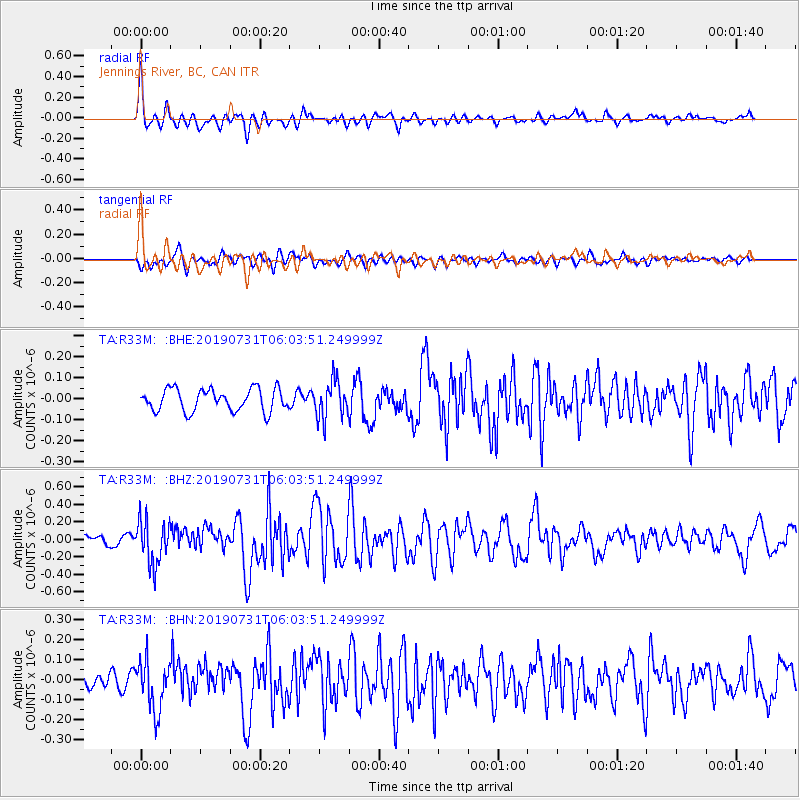
R33M Jennings River, BC, CAN - Earthquake Result Viewer
*The percent match for this event was below the threshold and hence no stack was calculated.
| Earthquake location: |
El Salvador |
| Earthquake latitude/longitude: |
13.3/-89.3 |
| Earthquake time(UTC): |
2019/07/31 (212) 05:54:55 GMT |
| Earthquake Depth: |
72 km |
| Earthquake Magnitude: |
5.9 Mww |
| Earthquake Catalog/Contributor: |
NEIC PDE/us |
|
| Network: |
TA USArray Transportable Network (new EarthScope stations) |
| Station: |
R33M Jennings River, BC, CAN |
| Lat/Lon: |
59.39 N/130.97 W |
| Elevation: |
1437 m |
|
| Distance: |
55.4 deg |
| Az: |
335.601 deg |
| Baz: |
128.18 deg |
| Ray Param: |
$rayparam |
*The percent match for this event was below the threshold and hence was not used in the summary stack. |
|
| Radial Match: |
73.03162 % |
| Radial Bump: |
400 |
| Transverse Match: |
61.177452 % |
| Transverse Bump: |
400 |
| SOD ConfigId: |
19053131 |
| Insert Time: |
2019-08-14 06:05:11.764 +0000 |
| GWidth: |
2.5 |
| Max Bumps: |
400 |
| Tol: |
0.001 |
|
Signal To Noise
| Channel | StoN | STA | LTA |
| TA:R33M: :BHZ:20190731T06:03:51.249999Z | 4.4436636 | 2.5445527E-7 | 5.7262497E-8 |
| TA:R33M: :BHN:20190731T06:03:51.249999Z | 3.4378977 | 1.246045E-7 | 3.624439E-8 |
| TA:R33M: :BHE:20190731T06:03:51.249999Z | 1.6873727 | 8.886944E-8 | 5.2667346E-8 |
| Arrivals |
| Ps | |
| PpPs | |
| PsPs/PpSs | |


