You are here: Home > Network List > TA - USArray Transportable Network (new EarthScope stations) Stations List
> Station R04C Big Horse Ranch, Ione, CA, USA > Earthquake Result Viewer
R04C Big Horse Ranch, Ione, CA, USA - Earthquake Result Viewer
| Earthquake location: |
South Of Fiji Islands |
| Earthquake latitude/longitude: |
-23.6/-180.0 |
| Earthquake time(UTC): |
2006/02/26 (057) 03:08:27 GMT |
| Earthquake Depth: |
535 km |
| Earthquake Magnitude: |
5.9 MB, 6.4 MW, 6.4 MW |
| Earthquake Catalog/Contributor: |
WHDF/NEIC |
|
| Network: |
TA USArray Transportable Network (new EarthScope stations) |
| Station: |
R04C Big Horse Ranch, Ione, CA, USA |
| Lat/Lon: |
38.26 N/120.94 W |
| Elevation: |
115 m |
|
| Distance: |
82.8 deg |
| Az: |
42.89 deg |
| Baz: |
232.468 deg |
| Ray Param: |
0.045095205 |
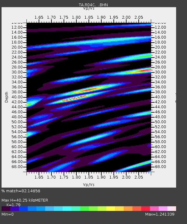
| Estimated Moho Depth: |
40.25 km |
| Estimated Crust Vp/Vs: |
1.79 |
| Assumed Crust Vp: |
6.597 km/s |
| Estimated Crust Vs: |
3.686 km/s |
| Estimated Crust Poisson's Ratio: |
0.27 |
|
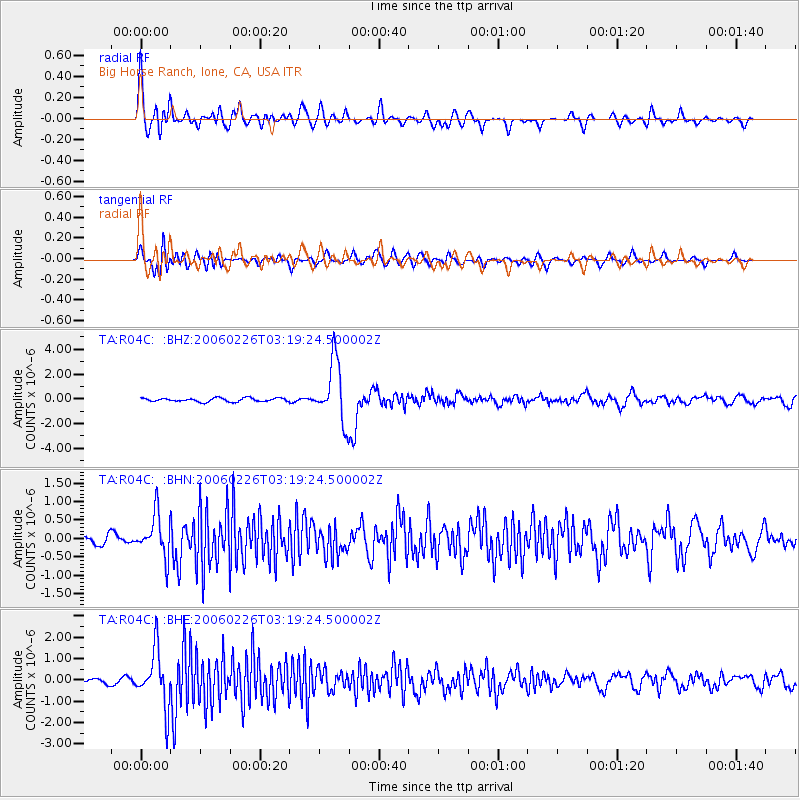
| Radial Match: |
82.14656 % |
| Radial Bump: |
400 |
| Transverse Match: |
70.15627 % |
| Transverse Bump: |
400 |
| SOD ConfigId: |
2422 |
| Insert Time: |
2010-03-07 02:31:13.066 +0000 |
| GWidth: |
2.5 |
| Max Bumps: |
400 |
| Tol: |
0.001 |
|
Signal To Noise
| Channel | StoN | STA | LTA |
| TA:R04C: :BHN:20060226T03:19:24.500002Z | 6.190519 | 5.724638E-7 | 9.247428E-8 |
| TA:R04C: :BHE:20060226T03:19:24.500002Z | 10.935105 | 1.3023257E-6 | 1.1909585E-7 |
| TA:R04C: :BHZ:20060226T03:19:24.500002Z | 16.788143 | 2.4407402E-6 | 1.4538476E-7 |
| Arrivals |
| Ps | 4.9 SECOND |
| PpPs | 17 SECOND |
| PsPs/PpSs | 22 SECOND |


