You are here: Home > Network List > TA - USArray Transportable Network (new EarthScope stations) Stations List
> Station R04C Big Horse Ranch, Ione, CA, USA > Earthquake Result Viewer
R04C Big Horse Ranch, Ione, CA, USA - Earthquake Result Viewer

| Earthquake location: |
East Of Kuril Islands |
| Earthquake latitude/longitude: |
46.2/154.5 |
| Earthquake time(UTC): |
2007/01/13 (013) 04:23:21 GMT |
| Earthquake Depth: |
10 km |
| Earthquake Magnitude: |
7.3 MB, 8.2 MS, 8.1 MW, 7.9 MW |
| Earthquake Catalog/Contributor: |
WHDF/NEIC |
|
| Network: |
TA USArray Transportable Network (new EarthScope stations) |
| Station: |
R04C Big Horse Ranch, Ione, CA, USA |
| Lat/Lon: |
38.26 N/120.94 W |
| Elevation: |
115 m |
|
| Distance: |
60.3 deg |
| Az: |
64.487 deg |
| Baz: |
307.288 deg |
| Ray Param: |
0.061644245 |
| Estimated Moho Depth: |
17.75 km |
| Estimated Crust Vp/Vs: |
1.69 |
| Assumed Crust Vp: |
6.597 km/s |
| Estimated Crust Vs: |
3.91 km/s |
| Estimated Crust Poisson's Ratio: |
0.23 |
|
| Radial Match: |
97.90331 % |
| Radial Bump: |
274 |
| Transverse Match: |
84.96089 % |
| Transverse Bump: |
400 |
| SOD ConfigId: |
2564 |
| Insert Time: |
2010-03-07 02:32:05.376 +0000 |
| GWidth: |
2.5 |
| Max Bumps: |
400 |
| Tol: |
0.001 |
|
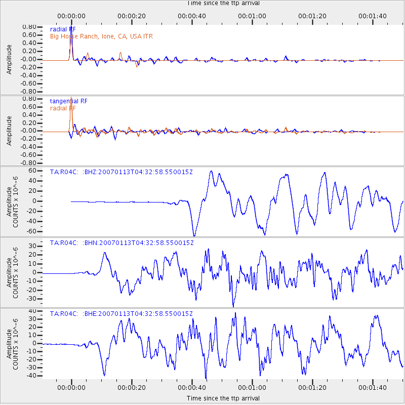
Signal To Noise
| Channel | StoN | STA | LTA |
| TA:R04C: :BHN:20070113T04:32:58.550015Z | 3.7356021 | 8.1205627E-7 | 2.1738298E-7 |
| TA:R04C: :BHE:20070113T04:32:58.550015Z | 9.921617 | 1.2954996E-6 | 1.3057344E-7 |
| TA:R04C: :BHZ:20070113T04:32:58.550015Z | 8.283674 | 2.4659307E-6 | 2.9768563E-7 |
| Arrivals |
| Ps | 1.9 SECOND |
| PpPs | 6.9 SECOND |
| PsPs/PpSs | 8.8 SECOND |


