You are here: Home > Network List > AK - Alaska Regional Network Stations List
> Station MESA Mesa, AK, USA > Earthquake Result Viewer
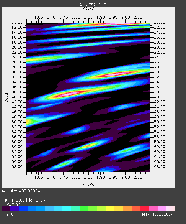
MESA Mesa, AK, USA - Earthquake Result Viewer
| Earthquake location: |
Vanuatu Islands |
| Earthquake latitude/longitude: |
-16.2/167.9 |
| Earthquake time(UTC): |
2019/07/31 (212) 15:02:33 GMT |
| Earthquake Depth: |
179 km |
| Earthquake Magnitude: |
6.6 mww |
| Earthquake Catalog/Contributor: |
NEIC PDE/us |
|
| Network: |
AK Alaska Regional Network |
| Station: |
MESA Mesa, AK, USA |
| Lat/Lon: |
60.18 N/141.95 W |
| Elevation: |
1907 m |
|
| Distance: |
86.1 deg |
| Az: |
22.605 deg |
| Baz: |
227.646 deg |
| Ray Param: |
0.04389794 |
| Estimated Moho Depth: |
10.0 km |
| Estimated Crust Vp/Vs: |
2.03 |
| Assumed Crust Vp: |
6.566 km/s |
| Estimated Crust Vs: |
3.235 km/s |
| Estimated Crust Poisson's Ratio: |
0.34 |
|
| Radial Match: |
88.92024 % |
| Radial Bump: |
400 |
| Transverse Match: |
88.97371 % |
| Transverse Bump: |
400 |
| SOD ConfigId: |
19053131 |
| Insert Time: |
2019-08-14 15:04:22.294 +0000 |
| GWidth: |
2.5 |
| Max Bumps: |
400 |
| Tol: |
0.001 |
|

Signal To Noise
| Channel | StoN | STA | LTA |
| AK:MESA: :BHZ:20190731T15:14:22.888001Z | 7.9343467 | 8.9869354E-7 | 1.13266225E-7 |
| AK:MESA: :BHN:20190731T15:14:22.888001Z | 1.9373659 | 1.8992051E-7 | 9.803028E-8 |
| AK:MESA: :BHE:20190731T15:14:22.888001Z | 3.4192562 | 2.9304252E-7 | 8.570358E-8 |
| Arrivals |
| Ps | 1.6 SECOND |
| PpPs | 4.5 SECOND |
| PsPs/PpSs | 6.1 SECOND |


