You are here: Home > Network List > AU - Australian Seismological Centre Stations List
> Station WB2 Warramunga Array, Australia > Earthquake Result Viewer
WB2 Warramunga Array, Australia - Earthquake Result Viewer
| Earthquake location: |
Vanuatu Islands |
| Earthquake latitude/longitude: |
-16.2/167.9 |
| Earthquake time(UTC): |
2019/07/31 (212) 15:02:33 GMT |
| Earthquake Depth: |
179 km |
| Earthquake Magnitude: |
6.6 mww |
| Earthquake Catalog/Contributor: |
NEIC PDE/us |
|
| Network: |
AU Australian Seismological Centre |
| Station: |
WB2 Warramunga Array, Australia |
| Lat/Lon: |
19.94 S/134.35 E |
| Elevation: |
388 m |
|
| Distance: |
32.1 deg |
| Az: |
258.171 deg |
| Baz: |
88.801 deg |
| Ray Param: |
0.07824168 |
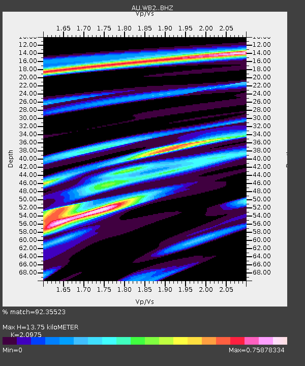
| Estimated Moho Depth: |
13.75 km |
| Estimated Crust Vp/Vs: |
2.10 |
| Assumed Crust Vp: |
6.642 km/s |
| Estimated Crust Vs: |
3.167 km/s |
| Estimated Crust Poisson's Ratio: |
0.35 |
|
| Radial Match: |
92.35523 % |
| Radial Bump: |
242 |
| Transverse Match: |
61.73646 % |
| Transverse Bump: |
400 |
| SOD ConfigId: |
19053131 |
| Insert Time: |
2019-08-14 15:05:01.664 +0000 |
| GWidth: |
2.5 |
| Max Bumps: |
400 |
| Tol: |
0.001 |
|

Signal To Noise
| Channel | StoN | STA | LTA |
| AU:WB2: :BHZ:20190731T15:08:13.750001Z | 19.495989 | 4.7704466E-6 | 2.446886E-7 |
| AU:WB2: :BHN:20190731T15:08:13.750001Z | 2.2348335 | 4.553182E-7 | 2.0373696E-7 |
| AU:WB2: :BHE:20190731T15:08:13.750001Z | 14.77489 | 2.9805044E-6 | 2.017277E-7 |
| Arrivals |
| Ps | 2.4 SECOND |
| PpPs | 6.0 SECOND |
| PsPs/PpSs | 8.4 SECOND |


