You are here: Home > Network List > AV - Alaska Volcano Observatory Stations List
> Station SPU Mount Spurr, Mount Spurr, Alaska > Earthquake Result Viewer
SPU Mount Spurr, Mount Spurr, Alaska - Earthquake Result Viewer
| Earthquake location: |
Vanuatu Islands |
| Earthquake latitude/longitude: |
-16.2/167.9 |
| Earthquake time(UTC): |
2019/07/31 (212) 15:02:33 GMT |
| Earthquake Depth: |
179 km |
| Earthquake Magnitude: |
6.6 mww |
| Earthquake Catalog/Contributor: |
NEIC PDE/us |
|
| Network: |
AV Alaska Volcano Observatory |
| Station: |
SPU Mount Spurr, Mount Spurr, Alaska |
| Lat/Lon: |
61.18 N/152.06 W |
| Elevation: |
800 m |
|
| Distance: |
83.4 deg |
| Az: |
18.27 deg |
| Baz: |
218.445 deg |
| Ray Param: |
0.04577569 |
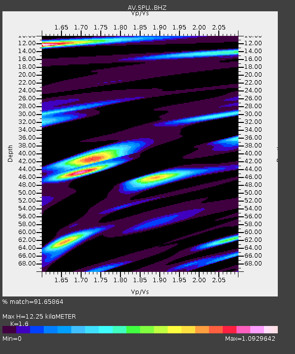
| Estimated Moho Depth: |
12.25 km |
| Estimated Crust Vp/Vs: |
1.60 |
| Assumed Crust Vp: |
6.566 km/s |
| Estimated Crust Vs: |
4.104 km/s |
| Estimated Crust Poisson's Ratio: |
0.18 |
|
| Radial Match: |
91.65864 % |
| Radial Bump: |
400 |
| Transverse Match: |
88.057655 % |
| Transverse Bump: |
400 |
| SOD ConfigId: |
19053131 |
| Insert Time: |
2019-08-14 15:05:25.824 +0000 |
| GWidth: |
2.5 |
| Max Bumps: |
400 |
| Tol: |
0.001 |
|
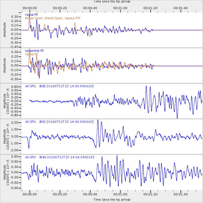
Signal To Noise
| Channel | StoN | STA | LTA |
| AV:SPU: :BHZ:20190731T15:14:09.640016Z | 24.908209 | 6.6575967E-7 | 2.6728525E-8 |
| AV:SPU: :BHN:20190731T15:14:09.640016Z | 7.4534883 | 2.3293558E-7 | 3.1251886E-8 |
| AV:SPU: :BHE:20190731T15:14:09.640016Z | 5.3739095 | 1.4992322E-7 | 2.7898354E-8 |
| Arrivals |
| Ps | 1.2 SECOND |
| PpPs | 4.7 SECOND |
| PsPs/PpSs | 5.9 SECOND |


