You are here: Home > Network List > AV - Alaska Volcano Observatory Stations List
> Station TASE Southeast, Tanaga Volcano, Alaska > Earthquake Result Viewer
TASE Southeast, Tanaga Volcano, Alaska - Earthquake Result Viewer
| Earthquake location: |
Vanuatu Islands |
| Earthquake latitude/longitude: |
-16.2/167.9 |
| Earthquake time(UTC): |
2019/07/31 (212) 15:02:33 GMT |
| Earthquake Depth: |
179 km |
| Earthquake Magnitude: |
6.6 mww |
| Earthquake Catalog/Contributor: |
NEIC PDE/us |
|
| Network: |
AV Alaska Volcano Observatory |
| Station: |
TASE Southeast, Tanaga Volcano, Alaska |
| Lat/Lon: |
51.83 N/178.04 W |
| Elevation: |
682 m |
|
| Distance: |
68.8 deg |
| Az: |
9.275 deg |
| Baz: |
194.454 deg |
| Ray Param: |
0.055564474 |
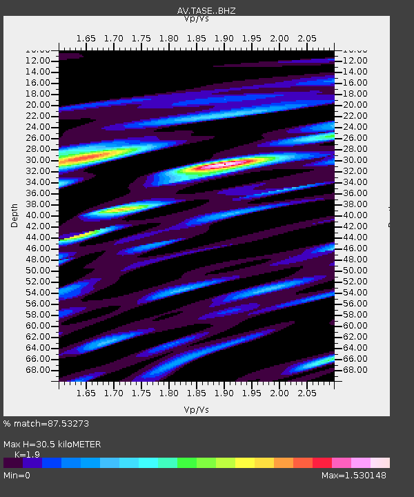
| Estimated Moho Depth: |
30.5 km |
| Estimated Crust Vp/Vs: |
1.90 |
| Assumed Crust Vp: |
6.048 km/s |
| Estimated Crust Vs: |
3.183 km/s |
| Estimated Crust Poisson's Ratio: |
0.31 |
|
| Radial Match: |
87.53273 % |
| Radial Bump: |
400 |
| Transverse Match: |
85.690186 % |
| Transverse Bump: |
400 |
| SOD ConfigId: |
19053131 |
| Insert Time: |
2019-08-14 15:05:42.330 +0000 |
| GWidth: |
2.5 |
| Max Bumps: |
400 |
| Tol: |
0.001 |
|

Signal To Noise
| Channel | StoN | STA | LTA |
| AV:TASE: :BHZ:20190731T15:12:47.479981Z | 9.83585 | 1.6876224E-6 | 1.7157872E-7 |
| AV:TASE: :BHN:20190731T15:12:47.479981Z | 3.068868 | 9.930742E-7 | 3.2359625E-7 |
| AV:TASE: :BHE:20190731T15:12:47.479981Z | 5.741493 | 1.6132692E-6 | 2.8098427E-7 |
| Arrivals |
| Ps | 4.7 SECOND |
| PpPs | 14 SECOND |
| PsPs/PpSs | 19 SECOND |


