You are here: Home > Network List > CN - Canadian National Seismograph Network Stations List
> Station PABB Port Alberni, BC, CA > Earthquake Result Viewer
PABB Port Alberni, BC, CA - Earthquake Result Viewer
| Earthquake location: |
Vanuatu Islands |
| Earthquake latitude/longitude: |
-16.2/167.9 |
| Earthquake time(UTC): |
2019/07/31 (212) 15:02:33 GMT |
| Earthquake Depth: |
179 km |
| Earthquake Magnitude: |
6.6 mww |
| Earthquake Catalog/Contributor: |
NEIC PDE/us |
|
| Network: |
CN Canadian National Seismograph Network |
| Station: |
PABB Port Alberni, BC, CA |
| Lat/Lon: |
49.22 N/124.81 W |
| Elevation: |
3.0 m |
|
| Distance: |
88.0 deg |
| Az: |
37.229 deg |
| Baz: |
242.461 deg |
| Ray Param: |
0.04249855 |
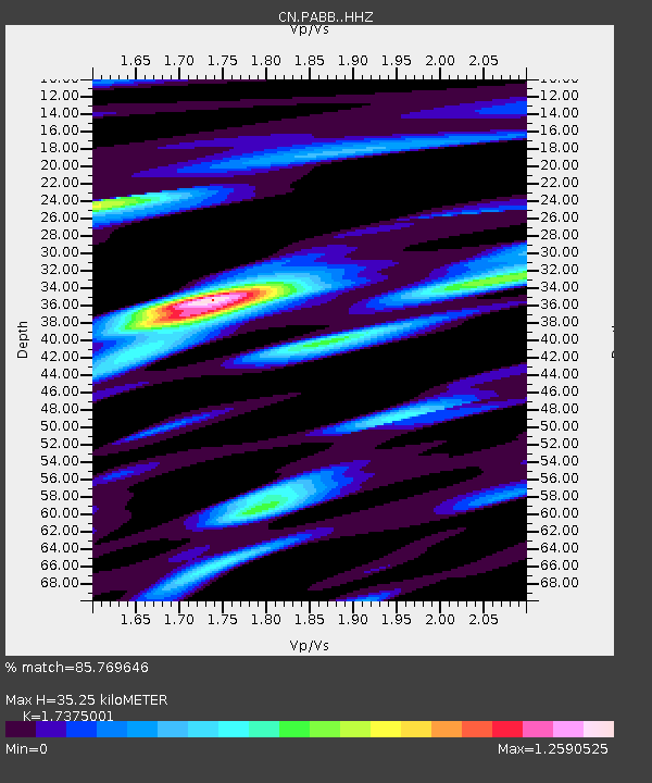
| Estimated Moho Depth: |
35.25 km |
| Estimated Crust Vp/Vs: |
1.74 |
| Assumed Crust Vp: |
6.391 km/s |
| Estimated Crust Vs: |
3.678 km/s |
| Estimated Crust Poisson's Ratio: |
0.25 |
|
| Radial Match: |
85.769646 % |
| Radial Bump: |
388 |
| Transverse Match: |
84.47797 % |
| Transverse Bump: |
334 |
| SOD ConfigId: |
19053131 |
| Insert Time: |
2019-08-14 15:07:23.597 +0000 |
| GWidth: |
2.5 |
| Max Bumps: |
400 |
| Tol: |
0.001 |
|

Signal To Noise
| Channel | StoN | STA | LTA |
| CN:PABB: :HHZ:20190731T15:14:32.119996Z | 7.4053345 | 6.2253065E-7 | 8.4065164E-8 |
| CN:PABB: :HHN:20190731T15:14:32.119996Z | 1.7670413 | 1.2376667E-7 | 7.004175E-8 |
| CN:PABB: :HHE:20190731T15:14:32.119996Z | 2.0702302 | 1.8290949E-7 | 8.835224E-8 |
| Arrivals |
| Ps | 4.2 SECOND |
| PpPs | 15 SECOND |
| PsPs/PpSs | 19 SECOND |


