You are here: Home > Network List > CN - Canadian National Seismograph Network Stations List
> Station PCLB Port Clements, BC, CA > Earthquake Result Viewer
PCLB Port Clements, BC, CA - Earthquake Result Viewer
| Earthquake location: |
Vanuatu Islands |
| Earthquake latitude/longitude: |
-16.2/167.9 |
| Earthquake time(UTC): |
2019/07/31 (212) 15:02:33 GMT |
| Earthquake Depth: |
179 km |
| Earthquake Magnitude: |
6.6 mww |
| Earthquake Catalog/Contributor: |
NEIC PDE/us |
|
| Network: |
CN Canadian National Seismograph Network |
| Station: |
PCLB Port Clements, BC, CA |
| Lat/Lon: |
53.72 N/132.52 W |
| Elevation: |
492 m |
|
| Distance: |
86.2 deg |
| Az: |
30.895 deg |
| Baz: |
236.114 deg |
| Ray Param: |
0.043843035 |
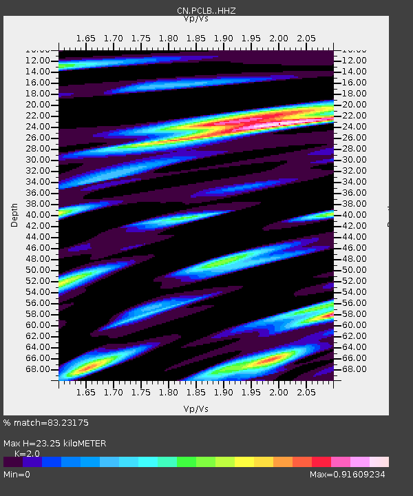
| Estimated Moho Depth: |
23.25 km |
| Estimated Crust Vp/Vs: |
2.00 |
| Assumed Crust Vp: |
6.183 km/s |
| Estimated Crust Vs: |
3.091 km/s |
| Estimated Crust Poisson's Ratio: |
0.33 |
|
| Radial Match: |
83.23175 % |
| Radial Bump: |
400 |
| Transverse Match: |
61.51439 % |
| Transverse Bump: |
400 |
| SOD ConfigId: |
19053131 |
| Insert Time: |
2019-08-14 15:07:24.400 +0000 |
| GWidth: |
2.5 |
| Max Bumps: |
400 |
| Tol: |
0.001 |
|

Signal To Noise
| Channel | StoN | STA | LTA |
| CN:PCLB: :HHZ:20190731T15:14:23.250001Z | 5.774954 | 1.0051868E-6 | 1.7405972E-7 |
| CN:PCLB: :HHN:20190731T15:14:23.250001Z | 2.2413247 | 4.134603E-7 | 1.844714E-7 |
| CN:PCLB: :HHE:20190731T15:14:23.250001Z | 2.758327 | 4.5129303E-7 | 1.6361115E-7 |
| Arrivals |
| Ps | 3.8 SECOND |
| PpPs | 11 SECOND |
| PsPs/PpSs | 15 SECOND |


