You are here: Home > Network List > CN - Canadian National Seismograph Network Stations List
> Station PHC Port Hardy, BC, CA > Earthquake Result Viewer
PHC Port Hardy, BC, CA - Earthquake Result Viewer
| Earthquake location: |
Vanuatu Islands |
| Earthquake latitude/longitude: |
-16.2/167.9 |
| Earthquake time(UTC): |
2019/07/31 (212) 15:02:33 GMT |
| Earthquake Depth: |
179 km |
| Earthquake Magnitude: |
6.6 mww |
| Earthquake Catalog/Contributor: |
NEIC PDE/us |
|
| Network: |
CN Canadian National Seismograph Network |
| Station: |
PHC Port Hardy, BC, CA |
| Lat/Lon: |
50.71 N/127.43 W |
| Elevation: |
32 m |
|
| Distance: |
87.2 deg |
| Az: |
35.11 deg |
| Baz: |
240.371 deg |
| Ray Param: |
0.043067813 |
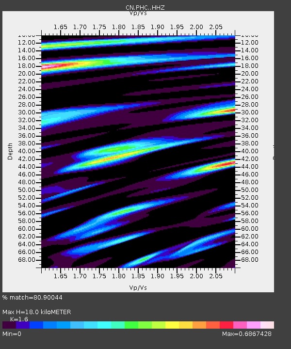
| Estimated Moho Depth: |
18.0 km |
| Estimated Crust Vp/Vs: |
1.60 |
| Assumed Crust Vp: |
6.545 km/s |
| Estimated Crust Vs: |
4.091 km/s |
| Estimated Crust Poisson's Ratio: |
0.18 |
|
| Radial Match: |
80.90044 % |
| Radial Bump: |
400 |
| Transverse Match: |
72.708145 % |
| Transverse Bump: |
400 |
| SOD ConfigId: |
19053131 |
| Insert Time: |
2019-08-14 15:07:25.399 +0000 |
| GWidth: |
2.5 |
| Max Bumps: |
400 |
| Tol: |
0.001 |
|

Signal To Noise
| Channel | StoN | STA | LTA |
| CN:PHC: :HHZ:20190731T15:14:28.450013Z | 5.258181 | 7.3212783E-7 | 1.3923595E-7 |
| CN:PHC: :HHN:20190731T15:14:28.450013Z | 1.3189098 | 1.3593086E-7 | 1.03063044E-7 |
| CN:PHC: :HHE:20190731T15:14:28.450013Z | 1.7653757 | 1.9384454E-7 | 1.0980356E-7 |
| Arrivals |
| Ps | 1.7 SECOND |
| PpPs | 7.0 SECOND |
| PsPs/PpSs | 8.7 SECOND |


