You are here: Home > Network List > CN - Canadian National Seismograph Network Stations List
> Station DI2B Dawson Inlet, BC, CA > Earthquake Result Viewer
DI2B Dawson Inlet, BC, CA - Earthquake Result Viewer
| Earthquake location: |
Vanuatu Islands |
| Earthquake latitude/longitude: |
-16.2/167.9 |
| Earthquake time(UTC): |
2019/07/31 (212) 15:02:33 GMT |
| Earthquake Depth: |
179 km |
| Earthquake Magnitude: |
6.6 mww |
| Earthquake Catalog/Contributor: |
NEIC PDE/us |
|
| Network: |
CN Canadian National Seismograph Network |
| Station: |
DI2B Dawson Inlet, BC, CA |
| Lat/Lon: |
53.20 N/132.48 W |
| Elevation: |
82 m |
|
| Distance: |
85.9 deg |
| Az: |
31.338 deg |
| Baz: |
236.18 deg |
| Ray Param: |
0.044034194 |
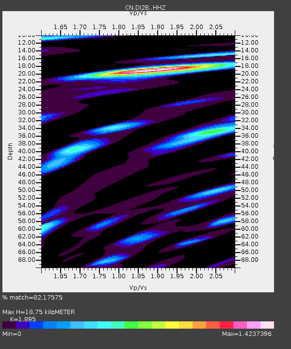
| Estimated Moho Depth: |
18.75 km |
| Estimated Crust Vp/Vs: |
1.89 |
| Assumed Crust Vp: |
6.183 km/s |
| Estimated Crust Vs: |
3.263 km/s |
| Estimated Crust Poisson's Ratio: |
0.31 |
|
| Radial Match: |
82.17575 % |
| Radial Bump: |
400 |
| Transverse Match: |
62.795986 % |
| Transverse Bump: |
400 |
| SOD ConfigId: |
19053131 |
| Insert Time: |
2019-08-14 15:07:34.539 +0000 |
| GWidth: |
2.5 |
| Max Bumps: |
400 |
| Tol: |
0.001 |
|

Signal To Noise
| Channel | StoN | STA | LTA |
| CN:DI2B: :HHZ:20190731T15:14:21.960023Z | 4.040425 | 9.0451385E-6 | 2.2386603E-6 |
| CN:DI2B: :HHN:20190731T15:14:21.960023Z | 1.0371896 | 1.6266835E-6 | 1.568357E-6 |
| CN:DI2B: :HHE:20190731T15:14:21.960023Z | 2.436638 | 2.734871E-6 | 1.1223952E-6 |
| Arrivals |
| Ps | 2.8 SECOND |
| PpPs | 8.6 SECOND |
| PsPs/PpSs | 11 SECOND |


