You are here: Home > Network List > CM - Red Sismologica Nacional de Columbia Stations List
> Station URI Uribia, Guajira, Columbia > Earthquake Result Viewer
URI Uribia, Guajira, Columbia - Earthquake Result Viewer
| Earthquake location: |
Southern Chile |
| Earthquake latitude/longitude: |
-43.3/-74.5 |
| Earthquake time(UTC): |
2016/12/25 (360) 14:22:28 GMT |
| Earthquake Depth: |
15 km |
| Earthquake Magnitude: |
7.7 Mi |
| Earthquake Catalog/Contributor: |
NEIC PDE/at |
|
| Network: |
CM Red Sismologica Nacional de Columbia |
| Station: |
URI Uribia, Guajira, Columbia |
| Lat/Lon: |
11.70 N/71.99 W |
| Elevation: |
68 m |
|
| Distance: |
54.8 deg |
| Az: |
3.01 deg |
| Baz: |
182.243 deg |
| Ray Param: |
0.06521884 |
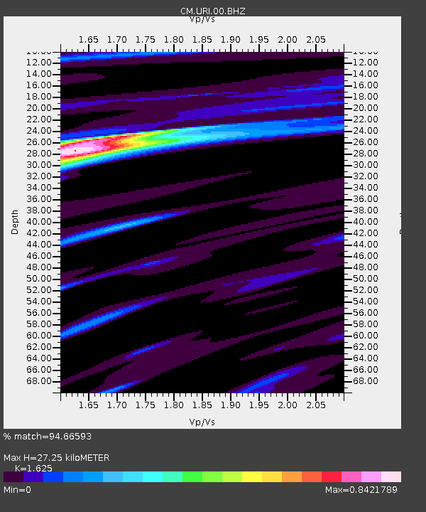
| Estimated Moho Depth: |
27.25 km |
| Estimated Crust Vp/Vs: |
1.62 |
| Assumed Crust Vp: |
5.738 km/s |
| Estimated Crust Vs: |
3.531 km/s |
| Estimated Crust Poisson's Ratio: |
0.20 |
|
| Radial Match: |
94.66593 % |
| Radial Bump: |
298 |
| Transverse Match: |
85.211205 % |
| Transverse Bump: |
400 |
| SOD ConfigId: |
1894071 |
| Insert Time: |
2017-01-08 14:27:15.787 +0000 |
| GWidth: |
2.5 |
| Max Bumps: |
400 |
| Tol: |
0.001 |
|

Signal To Noise
| Channel | StoN | STA | LTA |
| CM:URI:00:BHZ:20161225T14:31:26.018982Z | 26.884987 | 8.255984E-6 | 3.0708526E-7 |
| CM:URI:00:BHN:20161225T14:31:26.018982Z | 12.382899 | 5.157421E-6 | 4.1649542E-7 |
| CM:URI:00:BHE:20161225T14:31:26.018982Z | 2.3938773 | 9.4861315E-7 | 3.9626642E-7 |
| Arrivals |
| Ps | 3.1 SECOND |
| PpPs | 12 SECOND |
| PsPs/PpSs | 15 SECOND |


