You are here: Home > Network List > TA - USArray Transportable Network (new EarthScope stations) Stations List
> Station N02C Big Bar, CA, USA > Earthquake Result Viewer
N02C Big Bar, CA, USA - Earthquake Result Viewer
| Earthquake location: |
South Of Mariana Islands |
| Earthquake latitude/longitude: |
10.5/145.7 |
| Earthquake time(UTC): |
2007/09/30 (273) 02:08:30 GMT |
| Earthquake Depth: |
14 km |
| Earthquake Magnitude: |
6.4 MB, 7.1 MS, 6.9 MW, 6.9 MW |
| Earthquake Catalog/Contributor: |
WHDF/NEIC |
|
| Network: |
TA USArray Transportable Network (new EarthScope stations) |
| Station: |
N02C Big Bar, CA, USA |
| Lat/Lon: |
40.82 N/123.31 W |
| Elevation: |
0.0 m |
|
| Distance: |
84.0 deg |
| Az: |
49.729 deg |
| Baz: |
278.542 deg |
| Ray Param: |
0.045786567 |
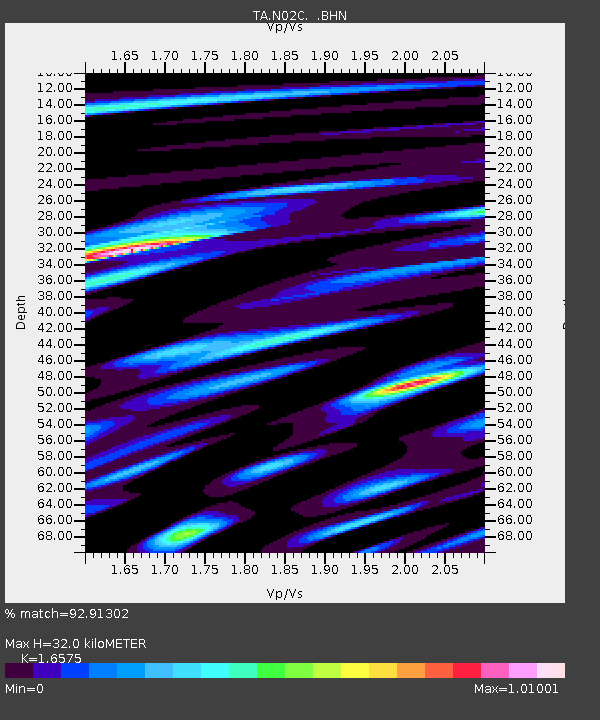
| Estimated Moho Depth: |
32.0 km |
| Estimated Crust Vp/Vs: |
1.66 |
| Assumed Crust Vp: |
6.566 km/s |
| Estimated Crust Vs: |
3.961 km/s |
| Estimated Crust Poisson's Ratio: |
0.21 |
|
| Radial Match: |
92.91302 % |
| Radial Bump: |
400 |
| Transverse Match: |
84.16238 % |
| Transverse Bump: |
400 |
| SOD ConfigId: |
2564 |
| Insert Time: |
2010-03-07 02:34:04.048 +0000 |
| GWidth: |
2.5 |
| Max Bumps: |
400 |
| Tol: |
0.001 |
|
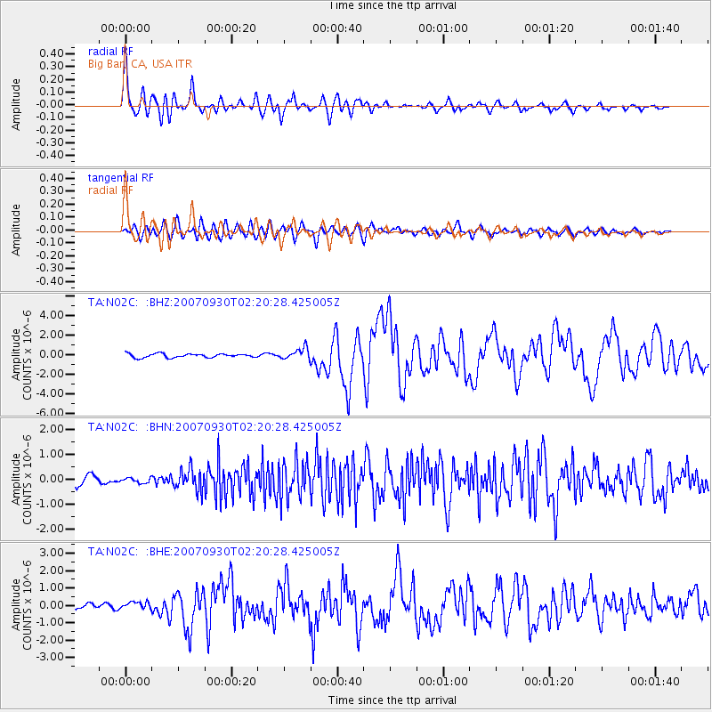
Signal To Noise
| Channel | StoN | STA | LTA |
| TA:N02C: :BHN:20070930T02:20:28.425005Z | 0.62928295 | 1.0300984E-7 | 1.63694E-7 |
| TA:N02C: :BHE:20070930T02:20:28.425005Z | 1.1462367 | 1.8888022E-7 | 1.6478292E-7 |
| TA:N02C: :BHZ:20070930T02:20:28.425005Z | 3.0335143 | 5.79874E-7 | 1.9115583E-7 |
| Arrivals |
| Ps | 3.3 SECOND |
| PpPs | 13 SECOND |
| PsPs/PpSs | 16 SECOND |


