You are here: Home > Network List > TA - USArray Transportable Network (new EarthScope stations) Stations List
> Station N02C Big Bar, CA, USA > Earthquake Result Viewer
N02C Big Bar, CA, USA - Earthquake Result Viewer
| Earthquake location: |
Southeast Of Loyalty Islands |
| Earthquake latitude/longitude: |
-21.1/169.3 |
| Earthquake time(UTC): |
2007/09/27 (270) 19:57:44 GMT |
| Earthquake Depth: |
9.0 km |
| Earthquake Magnitude: |
6.2 MB, 6.3 MS, 6.1 MW, 6.1 MW |
| Earthquake Catalog/Contributor: |
WHDF/NEIC |
|
| Network: |
TA USArray Transportable Network (new EarthScope stations) |
| Station: |
N02C Big Bar, CA, USA |
| Lat/Lon: |
40.82 N/123.31 W |
| Elevation: |
0.0 m |
|
| Distance: |
87.8 deg |
| Az: |
44.526 deg |
| Baz: |
239.629 deg |
| Ray Param: |
0.04309302 |
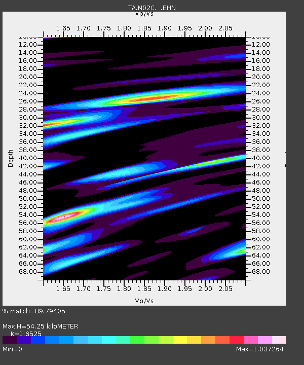
| Estimated Moho Depth: |
54.25 km |
| Estimated Crust Vp/Vs: |
1.65 |
| Assumed Crust Vp: |
6.566 km/s |
| Estimated Crust Vs: |
3.973 km/s |
| Estimated Crust Poisson's Ratio: |
0.21 |
|
| Radial Match: |
89.79405 % |
| Radial Bump: |
400 |
| Transverse Match: |
79.87654 % |
| Transverse Bump: |
400 |
| SOD ConfigId: |
2564 |
| Insert Time: |
2010-03-07 02:34:12.615 +0000 |
| GWidth: |
2.5 |
| Max Bumps: |
400 |
| Tol: |
0.001 |
|
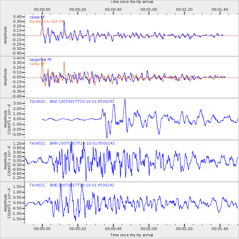
Signal To Noise
| Channel | StoN | STA | LTA |
| TA:N02C: :BHN:20070927T20:10:01.650024Z | 1.1059308 | 1.8268868E-7 | 1.6518997E-7 |
| TA:N02C: :BHE:20070927T20:10:01.650024Z | 2.1246939 | 2.2754497E-7 | 1.0709542E-7 |
| TA:N02C: :BHZ:20070927T20:10:01.650024Z | 5.549474 | 7.258399E-7 | 1.3079438E-7 |
| Arrivals |
| Ps | 5.5 SECOND |
| PpPs | 21 SECOND |
| PsPs/PpSs | 27 SECOND |


